Our mission is to help computational modelers develop, document, and share their computational models in accordance with community standards and good open science and software engineering practices. Model authors can publish their model source code in the Computational Model Library with narrative documentation as well as metadata that supports open science and emerging norms that facilitate software citation, computational reproducibility / frictionless reuse, and interoperability. Model authors can also request private peer review of their computational models. Models that pass peer review receive a DOI once published.
All users of models published in the library must cite model authors when they use and benefit from their code.
Please check out our model publishing tutorial and feel free to contact us if you have any questions or concerns about publishing your model(s) in the Computational Model Library.
Displaying 10 of 67 results for "Dean Bucciarelli" clear search
Enhancing recycling of construction materials; an agent based model with empirically based decision parameters
Igor Nikolic Claudia Binder Christof Knoeri Hans-Joerg Althaus | Published Sunday, October 21, 2012 | Last modified Monday, June 09, 2014This model allows for analyzing the most efficient levers for enhancing the use of recycled construction materials, and the role of empirically based decision parameters.
Neolithic Spread Model Version 1.0
Sean Bergin Salvador Pardo Gordo Joan Bernabeu Auban Michael Barton | Published Thursday, December 11, 2014 | Last modified Monday, December 31, 2018This model simulates different spread hypotheses proposed for the introduction of agriculture on the Iberian peninsula. We include three dispersal types: neighborhood, leapfrog, and ideal despotic distribution (IDD).
Agent based modeling of the effects of carbon payments and forest owner cooperatives on carbon storage and revenue in Pacific Northwest forestlands.
Dan Brown Pranab Roy Chowdhury | Published Tuesday, May 09, 2023The Olympic Peninsula ABM works as a virtual laboratory to simulate the existing forestland management practices as followed by different forestland owner groups in the Olympic Peninsula, Washington, and explore how they could shape the future provisions of multifunctional ecosystem services such as Carbon storage and revenue generation under the business-as-usual scenario as well as by their adaptation to interventions. Forestlands are socio-ecological systems that interact with economic, socio-cultural, and policy systems. Two intervention scenarios were introduced in this model to simulate the adaptation of landowner behavior and test the efficacy of policy instruments in promoting sustainable forest practices and fostering Carbon storage and revenue generation. (1) A market-linked carbon offset scheme that pays the forestland owners a financial incentive in the form of a yearly carbon rent. (2) An institutional intervention policy that allows small forest owners (SFLO) to cooperate for increased market access and benefits under carbon rent scenario. The model incorporates the heterogeneous contexts within which the forestland owners operate and make their forest management decisions by parameterizing relevant agent attributes and contextualizing their unique decision-making processes.
Recycling behavior of Chinese households
Igor Nikolic B Dijkhuizen M Van Den Hoven M Minderhoud N Wäckerlin | Published Monday, June 19, 2017 | Last modified Thursday, March 29, 2018The model represents empirically observed recycling behaviour of Chinese citizens, based on the theory of reasoned action (TRA), the theory of planned behaviour (TPB) and the theory of planned behaviour extended with situational factors (TPB+).
The AgriculTural LandscApe Simulator (ATLAS)
Hugo Thierry Claude Monteil Aude Vialatte Jean-Philippe Choisis Benoit Gaudou Hazel Parry | Published Monday, January 30, 2017 | Last modified Wednesday, May 10, 2017The spatially-explicit AgriculTuralLandscApe Simulator (ATLAS) simulates realistic spatial-temporal crop availability at the landscape scale through crop rotations and crop phenology.
MedLanD Modeling Laboratory
C Michael Barton Sean Bergin Isaac Ullah Gary Mayer Hessam Sarjoughian Helena Mitasova | Published Friday, May 08, 2015 | Last modified Thursday, December 14, 2017The MML is a hybrid modeling environment that couples an agent-based model of small-holder agropastoral households and a cellular landscape evolution model that simulates changes in erosion/deposition, soils, and vegetation.
Peer reviewed CHIME ABM of Hurricane Evacuation
C Michael Barton Sean Bergin Joshua Watts Joshua Alland Rebecca Morss | Published Monday, October 18, 2021 | Last modified Tuesday, January 04, 2022The Communicating Hazard Information in the Modern Environment (CHIME) agent-based model (ABM) is a Netlogo program that facilitates the analysis of information flow and protective decisions across space and time during hazardous weather events. CHIME ABM provides a platform for testing hypotheses about collective human responses to weather forecasts and information flow, using empirical data from historical hurricanes. The model uses real world geographical and hurricane data to set the boundaries of the simulation, and it uses historical hurricane forecast information from the National Hurricane Center to initiate forecast information flow to citizen agents in the model.
Exploring social psychology theory for modelling farmer decision-making
James Millington | Published Tuesday, September 18, 2012 | Last modified Saturday, April 27, 2013To investigate the potential of using Social Psychology Theory in ABMs of natural resource use and show proof of concept, we present an exemplary agent-based modelling framework that explicitly represents multiple and hierarchical agent self-concepts
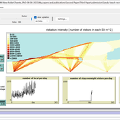
Sandy Beach Visitor Flow: An Agent-Based Model
Elham Bakhshianlamouki | Published Thursday, March 14, 2024The model is intended to simulate visitor spatial and temporal dynamics, encompassing their numbers, activities, and distribution along a coastline influenced by beach landscape design. Our primary focus is understanding how the spatial distribution of services and recreational facilities (e.g., beach width, entrance location, recreational facilities, parking availability) impacts visitation density. Our focus is not on tracking the precise visitation density but rather on estimating the areas most affected by visitor activity. This comprehension allows for assessing the diverse influences of beach layouts on spatial visitor density and, consequently, on the landscape’s biophysical characteristics (e.g., vegetation, fauna, and sediment features).
Artificial Long House Valley-Black Mesa
Lisa Sattenspiel Amy Warren | Published Thursday, March 19, 2020This model is an extension of the Artificial Long House Valley (ALHV) model developed by the authors (Swedlund et al. 2016; Warren and Sattenspiel 2020). The ALHV model simulates the population dynamics of individuals within the Long House Valley of Arizona from AD 800 to 1350. Individuals are aggregated into households that participate in annual agricultural and demographic cycles. The present version of the model incorporates features of the ALHV model including realistic age-specific fertility and mortality and, in addition, it adds the Black Mesa environment and population, as well as additional methods to allow migration between the two regions.
As is the case for previous versions of the ALHV model as well as the Artificial Anasazi (AA) model from which the ALHV model was derived (Axtell et al. 2002; Janssen 2009), this version makes use of detailed archaeological and paleoenvironmental data from the Long House Valley and the adjacent areas in Arizona. It also uses the same methods as the original AA model to estimate annual maize productivity of various agricultural zones within the Long House Valley. A new environment and associated methods have been developed for Black Mesa. Productivity estimates from both regions are used to determine suitable locations for households and farms during each year of the simulation.
Displaying 10 of 67 results for "Dean Bucciarelli" clear search