Our mission is to help computational modelers develop, document, and share their computational models in accordance with community standards and good open science and software engineering practices. Model authors can publish their model source code in the Computational Model Library with narrative documentation as well as metadata that supports open science and emerging norms that facilitate software citation, computational reproducibility / frictionless reuse, and interoperability. Model authors can also request private peer review of their computational models. Models that pass peer review receive a DOI once published.
All users of models published in the library must cite model authors when they use and benefit from their code.
Please check out our model publishing tutorial and feel free to contact us if you have any questions or concerns about publishing your model(s) in the Computational Model Library.
Displaying 10 of 238 results Netlogo clear search
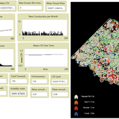
ZIP-Level Housing Supply Elasticity and Crash Dynamics: A GIS-Based Agent-Based Model of the Washington DC and Northern Virginia Metro Region
Mansoor Abdul Bari | Published Saturday, August 01, 2026 | Last modified Sunday, August 02, 2026This model tests whether local housing supply elasticity governs crash severity inside a single metropolitan housing market. Saiz (2010) established that across US metros, regions constrained by geography and regulation experience deeper boom-bust cycles than flexible ones. That finding is routinely applied downward to neighborhoods and ZIP codes as though the mechanism scaled without qualification.
The empirical record for the Washington DC and Northern Virginia region says it does not. Across 84 ZIP codes, measured supply elasticity ranges from 0.35 to 4.95 with a median of 1.21. The worst single-year price decline between 2007 and 2012 averaged 9.6 percent in constrained ZIP codes and 9.0 percent in flexible ones, a gap that cannot be distinguished from noise. Wide variation in the proposed cause, no meaningful separation in the proposed effect.
The model embeds households, houses and a metro-wide credit condition in the real ZIP geography of the region using three GIS layers and an empirical price panel. Local elasticity governs construction, exactly as theory predicts. Prices are driven by a shared macro drift schedule and, under the credit-amplified mode, by a leverage cycle with a financial accelerator and a deviation penalty. The design question is whether those shared forces are sufficient to override local supply differences at the sub-metropolitan scale.
…
MOSAIC: Mission-Oriented Self-Organization through Auctions, Incentives, and Coalitions
Katherin Molina Lorena Holguin | Published Friday, July 31, 2026MOSAIC is an agent-based NetLogo model of decentralized mission coordination among heterogeneous robots operating under partial observability, limited energy, spatially variable risk, dynamic communication, and individual and cooperative task requirements. Robots discover tasks locally, exchange task information through temporary communication links, submit capability-, energy-, deadline-, and risk-aware bids, compete for individual contracts, and form temporary coalitions for cooperative tasks.
The model integrates decentralized auctions, greedy capability-based coalition formation, contract release and reassignment, four reward regimes, reputation, adaptive bidding strategies, failure traceability, and mission-, network-, information-, inequality-, and coalition-level metrics. It operates without a centralized mission planner or global combinatorial assignment solver.
Seven paired-seed BehaviorSpace experiments comprising 690 official simulation runs evaluate baseline mission viability, reward regimes, communication structure, capability heterogeneity, cooperative-task demand, reputation and adaptive strategies, and mission-incentive strength. The results indicate that structural coordination capacity—particularly information reach, capability compatibility, and feasible coalition construction—has a stronger effect on mission completion than increasing incentive intensity within the tested architecture and parameter ranges.
…
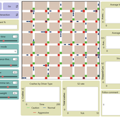
Amber Dilemma Zone: Driver Cognition and Signal Control in Urban Traffic
Mansoor Abdul Bari | Published Sunday, July 19, 2026This model is an extension of Wilensky’s (2003) Traffic Grid, a foundational NetLogo model of urban traffic flow. It embeds a dual-process cognitive architecture into each driver agent, transforming the original’s identical reactive units into cognitively heterogeneous individuals whose internal mental state evolves with experience; making the same intersection produce different decisions from different drivers, and different decisions from the same driver across occasions.
The core question the model addresses is the yellow-light dilemma zone: the seconds following amber onset in which a driver can neither stop safely nor clear the intersection before red. Field research documents that behavioral variance at this moment cannot be explained by geometry or legal obligation alone. This model provides the cognitive architecture that has been missing from traffic ABMs.
Each driver routes every amber-onset decision through either System 1 (fast, heuristic, automatic) or System 2 (slow, deliberative, prospect-theoretic), switching dynamically based on cognitive load, accumulated near-miss memory, and situational framing. The result is crash outcomes that are attributable, path-dependent, and sensitive to both driver disposition and signal infrastructure; none of which fixed-rule models can reproduce. Three signal control modes are included: fixed-cycle (replicating Wilensky’s original), adaptive-queue, and smart occupancy-based switching.
STiMUS-HAI: A Stigmergic–Mutualistic Agent-Based Model of Human-AI Collaboration on Shared Digital Artefacts
Yevgeny Patarakin | Published Monday, July 13, 2026STiMUS-HAI (Stigmergic–Mutualistic IMOI Model, Human-AI extension) is an agent-based model of teamwork in socio-technical systems where human and AI contributors collaborate through shared digital artefacts — wiki pages, code files, issue tickets, project cards, Scratch projects — represented as patches in a NetLogo world. It extends the human-only base model STiMUS v2.2, which established that two coordination mechanisms — stigmergy (indirect coordination through traces left in the environment) and mutualism (mutual benefit between contributors and the artefacts they tend) — can be decoupled: stigmergy decides where a contributor works, mutualism decides with what effort. STiMUS-HAI preserves this decoupling unchanged and adds two further theoretical questions: whether mixing AI agents into a human team distorts human coordination in ways that aggregate indicators hide, and whether AI’s cost to team outcomes depends on the type of work AI performs, not only on how much of it is present.
Two breeds of turtle — humans and ai-agents — follow identical target-selection, pheromone, and mutualism rules, so that any behavioural difference is attributable to team composition rather than a built-in advantage. The one designed asymmetry: AI agents never accumulate shared-mental-model and their motivation is fixed rather than adaptive. On top of this v3.0 baseline, v3.1 adds a task-type dimension to artefacts (“prediction” versus “judgment”, set via a judgment-share slider) that scales down AI edit-power specifically on judgment-requiring artefacts, and an ai-trust mechanic: humans build or lose trust in AI contributions based on the population-relative percentile rank of observed AI work quality (bottom-quartile work counts as an observed “error”), and that trust gates how much mutualistic benefit a human derives from continuing an AI’s work. Trust erodes quickly on a single error and recovers only after a streak of confirmed successes — an intentional asymmetry.
Peer reviewed STiMUS: A Stigmergic–Mutualistic Agent-Based Model of Teamwork on Shared Digital Artefacts (IMOI)
Yevgeny Patarakin | Published Friday, July 03, 2026 | Last modified Wednesday, July 22, 2026STiMUS (Stigmergic–Mutualistic IMOI Model) is an agent-based model of teamwork in socio-technical systems where contributors collaborate through shared digital artefacts — wiki pages, code files, issue tickets, project cards, Scratch projects — represented as patches in a NetLogo world. The model integrates two coordination mechanisms. Stigmergy is indirect coordination through traces left in a shared environment: each edit deposits a pheromone that diffuses to neighbouring patches and evaporates over time, so recent activity attracts further contributions. Mutualism is a reciprocal benefit loop in which valuable, well-maintained artefacts raise contributor motivation and shared understanding, while motivated contributors improve artefacts.
Contributors (turtles of the contributor breed) carry individual state: skill, motivation, shared-mental-model, specialty, benefit-gain, and an explicit-mode flag. At each tick every contributor selects a target artefact with an ant-colony-optimization-style rule weighing the artefact’s pheromone, incompleteness (1 - completeness), resource-value, and topic match between specialty and the artefact’s topic-tag; with probability p-explicit it instead takes the patch with the highest maintenance-need, modelling explicit task assignment. Each edit increases pheromone, quality, completeness and reuse-count, raises resource-value, lowers maintenance-need, and appends the editor to the artefact’s edit-authors list. When the previous last-editor-id differs from the current editor, the Edit Succession Ratio rises, the editor’s shared-mental-model grows, and a co-editing link is created — operationalising the idea that repeated cross-author succession on the same artefact builds shared understanding. Contributors’ motivation is updated from the benefit drawn from the visited artefact.
Each patch maintains a stigmergic layer (pheromone, quality, completeness, recentness, last-editor-id, edit-count, edit-authors) and a mutualistic layer (resource-value, reuse-count, maintenance-need, topic-tag), plus task flags (is-task?, task-complexity). Global monitors report the Edit Succession Ratio (ESR = cross-author-edits / total-edits, and an alternative esr-value = share of edited patches with more than one distinct author), mean-quality, mean-resource-value, a mutualism-index averaging contributor benefit and resource value, coediting-density (network density of the co-editing graph), active-pages-share, and task-completion-rate. The model logs every edit as a bipartite edge (tick, author_id, pageid, specialty, topic_tag, quality), exportable to CSV.
…
Peer reviewed Kenya ITN Agent-Based Microsimulation (2003–2024)
Wooyoung Kim Hosang Shin | Published Saturday, April 18, 2026 | Last modified Tuesday, June 16, 2026An agent-based microsimulation of insecticide-treated net (ITN) distribution and adoption in Kenya (2003–2024), integrating the Theory of Planned Behaviour, Rogers diffusion, Weibull net decay, and a GPS-based two-layer social network. 8,561 household agents calibrated via Approximate Bayesian Computation to six DHS/MIS survey waves, achieving 2.42 pp mean absolute error on Kenya-level ownership. The analysis chain supports mechanism counterfactuals and policy experiments on equity outcomes of ITN distribution strategies.
A simulation model for Dublin city
umesh7lowe | Published Friday, April 10, 2026An agent-based model of urban travel behaviour in Dublin, Ireland, built in NetLogo and empirically grounded in 2016 travel survey data. Each agent represents a Dublin resident initialised with real socio-demographic attributes — including age, gender, household size and car ownership, income, driving licence status, and access to local amenities — alongside observed trip characteristics such as distance, travel time, and trip type (work, shopping, leisure).
At each time step, agents choose between four transport modes (car, public transport, cycling, and walking) across short, medium, and long trips. Mode choice is governed by a preference vector that weighs personal need satisfaction against social influence from neighbouring agents reflecting consumat framework. Satisfaction evolves dynamically based on cost (incorporating Irish motor tax bands and per-km operating rates), travel time, and trip-type suitability, with an uncertainty parameter capturing variability in perceived utility over time.
The model tracks aggregate modal shares and total CO2 emission at each tick, enabling exploration of how policy interventions — such as fuel taxation, public transport pricing, or active travel incentives — might shift the city’s travel demand profile over 100 simulated days.
VIBE (Visible and Interconnected Behavioral Expectations Model)
Wenhan Feng | Published Friday, March 20, 2026This model aims to study the dynamic propagation of individual behaviour within social networks, focusing on how normative expectations (NE) and experiential expectations (EE) jointly influence behavioural decisions. It also explores the long-term effects of different intervention scenarios (such as enhancing visibility, considering indirect social links, and education) on behavioural propagation patterns and the overall behaviour of the group.
The model was developed in NetLogo 6.4. It generates simulated groups based on large-scale survey data, utilizing NetLogo’s CSV, Table, and Matrix extensions. The model also employs the NW extension to enable network analysis functionality.
The model is designed for research “Shaping social norms to promote individual response behavior in public crises: An agent-based modeling approach” in Journal of Cleaner Production, Volume 554, 8 April 2026, 148014
https://doi.org/10.1016/j.jclepro.2026.148014
Negotiation Lab 1.0
Julián Arévalo | Published Friday, March 20, 2026Negotiation Lab 1.0 is an agent-based model of peace negotiations that explores how the parties’ readiness — their motivation and optimism to engage in talks — evolves dynamically throughout the negotiation process. The model reconceptualizes readiness as an adaptive state variable that is continuously updated through feedback from negotiation outcomes, rather than a static precondition assessed at the onset of talks.
The model simulates two parties negotiating a multi-issue agenda. In each round, parties allocate effort to the current sub-issue; outcomes depend on their joint effort and a stochastic component representing external factors. Results feed back into each party’s readiness, shaping subsequent engagement. The negotiation ends either when all agenda items are resolved (agreement) or when a party’s readiness falls below a critical threshold (breakdown).
Key parameters include the initial readiness of each party, agenda structure (balanced, hard, easy, red, or random), type of negotiation (from highly cooperative to highly competitive), and each party’s effort strategy (always high, always low, random, or pseudo tit-for-tat). The model shows that while initial readiness is associated with negotiation outcomes, it is neither necessary nor sufficient to determine them: process variables — the type of interaction, agenda design, and adaptive effort strategies — exert comparatively larger effects on outcomes. Identical initial conditions can produce widely divergent trajectories, illustrating path dependence and sensitivity to feedback dynamics.
The model is implemented in NetLogo 7.0 and is documented using the ODD+D protocol. It is associated with the paper “Beyond Initial Conditions: How Adaptive Readiness Shapes Peace Negotiation Outcomes” (Arévalo, under review).
NetLogo Model of Spatial Eviction in Attraction-Repulsion Opinion Dynamics
poyeker | Published Friday, March 13, 2026A reproducible NetLogo implementation of a spatial attraction-repulsion opinion model with eviction-driven relocation. Agents interact locally, converge with similar neighbors, diverge from dissimilar neighbors, and may evict the most dissimilar neighbor to a random empty location. Parameter sweeps reveal transitions among extremist, mixed, and consensus regimes, with outputs including phase diagrams, opinion distributions, and Moran’s I. The model is intended to reproduce and extend results on how exclusion frequency changes polarization outcomes.
Displaying 10 of 238 results Netlogo clear search