Our mission is to help computational modelers develop, document, and share their computational models in accordance with community standards and good open science and software engineering practices. Model authors can publish their model source code in the Computational Model Library with narrative documentation as well as metadata that supports open science and emerging norms that facilitate software citation, computational reproducibility / frictionless reuse, and interoperability. Model authors can also request private peer review of their computational models. Models that pass peer review receive a DOI once published.
All users of models published in the library must cite model authors when they use and benefit from their code.
Please check out our model publishing tutorial and feel free to contact us if you have any questions or concerns about publishing your model(s) in the Computational Model Library.
Displaying 10 of 11 results monitoring clear search
MASTOC-LLM (Multi-Agent System Tragedy of the Commons - Large Language Models)
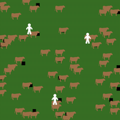
Thomas Tuoti | Published Monday, May 18, 2026 | Last modified Tuesday, May 19, 2026MASTOC-LLM extends the classic Multi-Agent System Tragedy of the Commons (MASTOC) model by replacing hard-coded behavioral rules with autonomous decision-making powered by large language models (LLMs). Three heterogeneous agents manage herds of cows on a shared grassland commons. Each tick, an agent receives a structured prompt describing current resource levels, its own herd size, peer behavior, and — optionally — a rolling memory of recent rounds and messages from neighboring agents. The LLM returns a stocking decision (add, remove, or hold cows) together with a natural-language rationale and, when communication is enabled, a short message to broadcast to peers.
The model is designed to test whether LLM agents spontaneously develop Ostrom-style common-pool resource governance (mutual monitoring, graduated sanctions, graduated rule revision) or instead fall into identifiable failure modes. Preliminary experiments with Claude Haiku 4.5, GPT-5.4-mini, and DeepSeek R1:32b have revealed four recurring collapse patterns — Cooperative Paralysis, Defection Cascade, Overshoot-Panic, and Hybrid Architecture Failure — whose onset timing is sensitive to memory length, inter-agent communication, and the post-training alignment approach of the underlying model.
MASTOC-LLM is intended as a laboratory for generative agent-based modelling (GABM) methodology: it provides a clean, well-understood commons baseline against which LLM behavioral hypotheses can be systematically tested and compared across models, parameter sweeps, and alignment regimes.
An agent-based model of scapegoating
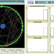
Carlos Paes | Published Thursday, August 28, 2025 | Last modified Thursday, August 28, 2025This agent-based model investigates scapegoating as a social mechanism of crisis management. Inspired by René Girard’s mimetic theory, it simulates how individual tension accumulates and spreads across a small-world network. When tension exceeds certain thresholds, leaders emerge and accuse marginalized agents, who may attempt to transfer blame to substitutes. If scapegoating occurs, collective tension decreases, but victims become isolated while leaders consolidate temporary authority. This simulation provides a conceptual and methodological framework for exploring how collective blame, crisis contagion, and leadership paradoxes emerge in complex networks. It can also be extended with empirical data, such as social media dynamics of online harassment and virtual lynching, offering potential applications for both theoretical research and practical crisis monitoring.
The SAFIRe model : Simulation of Agents for Fertility, Integrated Energy, Food security, and Reforestation
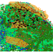
Etienne DELAY Lucas Broutin | Published Thursday, June 12, 2025The SAFIRe model (Simulation of Agents for Fertility, Integrated Energy, Food Security, and Reforestation) is an agent-based model co-developed with rural communities in Senegal’s Groundnut Basin. Its purpose is to explore how local farming and pastoral practices affect the regeneration of Faidherbia albida trees, which are essential for maintaining soil fertility and supporting food security through improved millet production. The model supports collective reflection on how different social and ecological factors interact, particularly around firewood demand, livestock pressure, and agricultural intensification.
The model simulates a 100-hectare agricultural landscape where agents (farmers, shepherds, woodcutters, and supervisors) interact with trees, land parcels, and each other. It incorporates seasonality, crop rotation, tree growth and cutting, livestock feeding behaviors, and farmers’ engagement in sapling protection through Assisted Natural Regeneration (ANR). Two types of surveillance strategies are compared: community-led monitoring and delegated surveillance by forestry authorities. Farmer engagement evolves over time based on peer influence, meeting participation, and the success of visible tree regeneration efforts.
SAFIRe integrates participatory modeling (ComMod and ComExp) and a backcasting approach (ACARDI) to co-produce scenarios rooted in local aspirations. It was explored using the OpenMole platform, allowing stakeholders to test a wide range of future trajectories and analyze the sensitivity of key parameters (e.g., discussion frequency, time in fields). The model’s outcomes not only revealed unexpected insights—such as the hidden role of farmers in tree loss—but also led to real-world actions, including community nursery creation and behavioral shifts toward tree care. SAFIRe illustrates how agent-based modeling can become a tool for social learning and collective action in socio-ecological systems.
Agent-Based Model of Transhumant Decision-Making Processes in Senegal
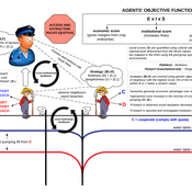
Cheick Amed Diloma Gabriel TRAORE Etienne DELAY Alassane Bah Djibril Diop | Published Wednesday, July 03, 2024Sahelian transhumance is a type of socio-economic and environmental pastoral mobility. It involves the movement of herds from their terroir of origin (i.e., their original pastures) to one or more host terroirs, followed by a return to the terroir of origin. According to certain pastoralists, the mobility of herds is planned to prevent environmental degradation, given the continuous dependence of these herds on their environment. However, these herds emit Greenhouse Gases (GHGs) in the spaces they traverse. Given that GHGs contribute to global warming, our long-term objective is to quantify the GHGs emitted by Sahelian herds. The determination of these herds’ GHG emissions requires: (1) the artificial replication of the transhumance, and (2) precise knowledge of the space used during their transhumance.
This article presents the design of an artificial replication of the transhumance through an agent-based model named MSTRANS. MSTRANS determines the space used by transhumant herds, based on the decision-making process of Sahelian transhumants.
MSTRANS integrates a constrained multi-objective optimization problem and algorithms into an agent-based model. The constrained multi-objective optimization problem encapsulates the rationality and adaptability of pastoral strategies. Interactions between a transhumant and its socio-economic network are modeled using algorithms, diffusion processes, and within the multi-objective optimization problem. The dynamics of pastoral resources are formalized at various spatio-temporal scales using equations that are integrated into the algorithms.
The results of MSTRANS are validated using GPS data collected from transhumant herds in Senegal. MSTRANS results highlight the relevance of integrated models and constrained multi-objective optimization for modeling and monitoring the movements of transhumant herds in the Sahel. Now specialists in calculating greenhouse gas emissions have a reproducible and reusable tool for determining the space occupied by transhumant herds in a Sahelian country. In addition, decision-makers, pastoralists, veterinarians and traders have a reproducible and reusable tool to help them make environmental and socio-economic decisions.
Community Forest Management with Monitoring and Sanctioning
Maya Lapp Colby Long | Published Wednesday, April 29, 2020 | Last modified Friday, July 23, 2021This NetLogo ABM builds on Elena Vallino’s model of Loggers using community-based natural resource management for a forest ecosystem. In it we introduce an alternative mechanism for Logger cheating and enforcement of CBNRM rules.
Agent-based model for the socio-economic monitoring of visitor streams
Stefan Mohr | Published Saturday, January 20, 2018Due to the large extent of the Harz National Park, an accurate measurement of visitor numbers and their spatiotemporal distribution is not feasible. This model demonstrates the possibility to simulate the streams of visitors with ABM methodology.
The Groundwater Commons Game
Juan Castilla-Rho Rodrigo Rojas | Published Thursday, May 11, 2017 | Last modified Saturday, September 16, 2017The Groundwater Commons Game synthesises and extends existing work on human cooperation and collective action, to elucidate possible determinants and pathways to regulatory compliance in groundwater systems globally.
Eliminating hepatitis C virus as a public health threat among HIV-positive men who have sex with men
Nick Scott Mark Stoove David P Wilson Olivia Keiser Carol El-Hayek Joseph Doyle Margaret Hellard | Published Wednesday, October 12, 2016 | Last modified Sunday, December 16, 2018We compare three model estimates for the time and treatment requirements to eliminate HCV among HIV-positive MSM in Victoria, Australia: a compartmental model; an ABM parametrized by surveillance data; and an ABM with a more heterogeneous population.
Simulation of Self-enforcing Agreement in Cooperative Teams
Hang Xiong | Published Friday, April 01, 2016This is an agent-based model of the implementation of the self-enforcing agreement in cooperative teams.
The purpose of this model is to enhance a basic ABM through a simple set of rules identified using the activity-driven models in order to produce more realistic patterns of pedestrian movement.
Displaying 10 of 11 results monitoring clear search