Our mission is to help computational modelers develop, document, and share their computational models in accordance with community standards and good open science and software engineering practices. Model authors can publish their model source code in the Computational Model Library with narrative documentation as well as metadata that supports open science and emerging norms that facilitate software citation, computational reproducibility / frictionless reuse, and interoperability. Model authors can also request private peer review of their computational models. Models that pass peer review receive a DOI once published.
All users of models published in the library must cite model authors when they use and benefit from their code.
Please check out our model publishing tutorial and feel free to contact us if you have any questions or concerns about publishing your model(s) in the Computational Model Library.
Displaying 10 of 203 results ABM clear search
Demography, Industry and Residential Choice (DIReC) model
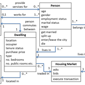
Jiaqi Ge | Published Wednesday, September 04, 2019The integrated and spatially-explicit ABM, called DIReC (Demography, Industry and Residential Choice), has been developed for Aberdeen City and the surrounding Aberdeenshire (Ge, Polhill, Craig, & Liu, 2018). The model includes demographic (individual and household) models, housing infrastructure and occupancy, neighbourhood quality and evolution, employment and labour market, business relocation, industrial structure, income distribution and macroeconomic indicators. DIReC includes a detailed spatial housing model, basing preference models on house attributes and multi-dimensional neighbourhood qualities (education, crime, employment etc.).
The dynamic ABM simulates the interactions between individuals, households, the labour market, businesses and services, neighbourhoods and economic structures. It is empirically grounded using multiple data sources, such as income and gender-age distribution across industries, neighbourhood attributes, business locations, and housing transactions. It has been used to study the impact of economic shocks and structural changes, such as the crash of oil price in 2014 (the Aberdeen economy heavily relies on the gas and oil sector) and the city’s transition from resource-based to a green economy (Ge, Polhill, Craig, & Liu, 2018).
PowerGen-ABM
Muhammad Indra Al Irsyad Anthony Halog Rabindra Nepal Deddy Priatmodjo Koesrindartoto | Published Sunday, August 04, 2019PowerGen-ABM is an optimisation model for power plant expansions from 2010 to 2025 with Indonesian electricity systems as the case study. PowerGen-ABM integrates three approaches: techno-economic analysis (TEA), linear programming (LP), and input-output analysis (IOA) and environmental analysis. TEA is based on the revenue requirement (RR) formula by UCDavis (2016), and the environmental analysis accounts for resource consumption (i.e., steel, concrete, aluminium, and energy) and carbon dioxide equivalent (CO2e) emissions during the construction and operational stages of power plants.
An agent-based artificial stock with a dynamic investor network
Matthew Oldham | Published Tuesday, June 25, 2019The model is an agent-based artificial stock market where investors connect in a dynamic network. The network is dynamic in the sense that the investors, at specified intervals, decide whether to keep their current adviser (those investors they receive trading advise from). The investors also gain information from a private source and share public information about the risky asset. Investors have different tendencies to follow the different information sources, consider differing amounts of history, and have different thresholds for investing.
MERCURY extension: population
Tom Brughmans | Published Thursday, May 23, 2019This model is an extended version of the original MERCURY model (https://www.comses.net/codebases/4347/releases/1.1.0/ ) . It allows for experiments to be performed in which empirically informed population sizes of sites are included, that allow for the scaling of the number of tableware traders with the population of settlements, and for hypothesised production centres of four tablewares to be used in experiments.
Experiments performed with this population extension and substantive interpretations derived from them are published in:
Hanson, J.W. & T. Brughmans. In press. Settlement scale and economic networks in the Roman Empire, in T. Brughmans & A.I. Wilson (ed.) Simulating Roman Economies. Theories, Methods and Computational Models. Oxford: Oxford University Press.
…
ABM Household Decision Making on Solar Energy using Theory of Planned Behaviour
Tatiana Filatova Hannah Muelder | Published Tuesday, May 21, 2019The model aims at estimating household energy consumption and the related greenhouse gas (GHG) emissions reduction based on the behavior of the individual household under different operationalizations of the Theory of Planned Behaviour (TPB).
The original model is developed as a tool to explore households decisions regarding solar panel investments and cumulative consequences of these individual choices (i.e. diffusion of PVs, regional emissions savings, monetary savings). We extend the model to explore a methodological question regarding an interpretation of qualitative concepts from social science theories, specifically Theory of Planned Behaviour in a formal code of quantitative agent-based models (ABMs). We develop 3 versions of the model: one TPB-based ABM designed by the authors and two alternatives inspired by the TPB-ABM of Schwarz and Ernst (2009) and the TPB-ABM of Rai and Robinson (2015). The model is implemented in NetLogo.
The code shared here accompanies the paper at https://doi.org/10.1371/journal.pone.0208451. It simulates the effects of various economic trade scenarios on the phenomenon of the ‘disappearing middle’ in the Scottish beef and dairy farming industries. The ‘disappearing middle’ is a situation in which there is a simultaneous observed decline in medium-sized enterprises and rise in the number of small and large-scale enterprises.
Diffusion of Vegetarian Diet
Patrick Taillandier Nicolas Salliou Rallou Thomopoulos | Published Monday, April 29, 2019Model of diffusion of vegetarian diets coupling ABM and argumentation framework
BENCHv.2 model
Leila Niamir | Published Sunday, April 28, 2019The BENCH agent-based model is designed and developed to study shifts in residential energy use and corresponding emissions driven by behavioral changes among heterogeneous individuals.
WOLVES - simulating wolf reappearance in the Netherlands
Kim van Vliet Zoë Delamore | Published Saturday, April 27, 2019This is an agent-based model, simulating wolf (Canis Lupus) reappearance in the Netherlands. The model’s purpose is to allow researchers to investigate the reappearance of wolves in the Netherlands and the possible effect of human interference. Wolf behaviour is modelled according to the literature. The suitability of the Dutch landscape for wolf settlement has been determined by Lelieveld (2012) [1] and is transformed into a colour-coded map of the Netherlands. The colour-coding is the main determinant of wolf settlement. Human involvement is modelled through the public opinion, which varies according to the size, composition and behaviour of the wolf population.
[1] Lelieveld, G.: Room for wolf comeback in the Netherlands, (2012).
Samambaia Basin - Hydro-ABM
Pedro Phelipe Gonçalves Porto | Published Sunday, April 07, 2019 | Last modified Monday, May 06, 2019This model is a tool to support water management on Samambaia Basin. On it you can explore different scenarios of policy, management and externalities that could influence the water uses. (Scenarios already tested include less rain and payment on water use)
Displaying 10 of 203 results ABM clear search