Our mission is to help computational modelers develop, document, and share their computational models in accordance with community standards and good open science and software engineering practices. Model authors can publish their model source code in the Computational Model Library with narrative documentation as well as metadata that supports open science and emerging norms that facilitate software citation, computational reproducibility / frictionless reuse, and interoperability. Model authors can also request private peer review of their computational models. Models that pass peer review receive a DOI once published.
All users of models published in the library must cite model authors when they use and benefit from their code.
Please check out our model publishing tutorial and feel free to contact us if you have any questions or concerns about publishing your model(s) in the Computational Model Library.
Displaying 10 of 10 results pollution clear search
Peer reviewed Labor and environment in global value chains: An evolutionary policy study with a three-sector and two-region agent-based macroeconomic model
Lena Gerdes Manuel Scholz-Wäckerle Bernhard Rengs | Published Wednesday, December 22, 2021With this model, we investigate resource extraction and labor conditions in the Global South as well as implications for climate change originating from industry emissions in the North. The model serves as a testbed for simulation experiments with evolutionary political economic policies addressing these issues. In the model, heterogeneous agents interact in a self-organizing and endogenously developing economy. The economy contains two distinct regions – an abstract Global South and Global North. There are three interlinked sectors, the consumption good–, capital good–, and resource production sector. Each region contains an independent consumption good sector, with domestic demand for final goods. They produce a fictitious consumption good basket, and sell it to the households in the respective region. The other sectors are only present in one region. The capital good sector is only found in the Global North, meaning capital goods (i.e. machines) are exclusively produced there, but are traded to the foreign as well as the domestic market as an intermediary. For the production of machines, the capital good firms need labor, machines themselves and resources. The resource production sector, on the other hand, is only located in the Global South. Mines extract resources and export them to the capital firms in the North. For the extraction of resources, the mines need labor and machines. In all three sectors, prices, wages, number of workers and physical capital of the firms develop independently throughout the simulation. To test policies, an international institution is introduced sanctioning the polluting extractivist sector in the Global South as well as the emitting industrial capital good producers in the North with the aim of subsidizing innovation reducing environmental and social impacts.
A Simple Agent Based Modeling Tool for Plastic and Debris Tracking in Oceans
Subu Kandaswamy Koushik Sura Bhaskar Sai Amulya Murukutla Sai Pranay Raju Chinthala Abhishek Bobbillapati | Published Monday, October 04, 2021Plastics and the pollution caused by their waste have always been a menace to both nature and humans. With the continual increase in plastic waste, the contamination due to plastic has stretched to the oceans. Many plastics are being drained into the oceans and rose to accumulate in the oceans. These plastics have seemed to form large patches of debris that keep floating in the oceans over the years. Identification of the plastic debris in the ocean is challenging and it is essential to clean plastic debris from the ocean. We propose a simple tool built using the agent-based modeling framework NetLogo. The tool uses ocean currents data and plastic data both being loaded using GIS (Geographic Information System) to simulate and visualize the movement of floatable plastic and debris in the oceans. The tool can be used to identify the plastic debris that has been piled up in the oceans. The tool can also be used as a teaching aid in classrooms to bring awareness about the impact of plastic pollution. This tool could additionally assist people to realize how a small plastic chunk discarded can end up as large debris drifting in the oceans. The same tool might help us narrow down the search area while looking out for missing cargo and wreckage parts of ships or flights. Though the tool does not pinpoint the location, it might help in reducing the search area and might be a rudimentary alternative for more computationally expensive models.
Pollution-development Tradeoffs in Nigeria--an Agent-based Model
Christopher Thron | Published Thursday, June 03, 2021Like many developing countries, Nigeria is faced with a number of tradeoffs that pit rapid economic development against environmental preservation. Environmentally sustainable, “green” economic development is slower, more costly, and more difficult than unrestricted, unregulated economic growth. The mathematical model that we develop in this code suggests that widespread public awareness of environmental issues is insufficient to prevent the tendency towards sacrificing the environment for the sake of growth. Even if people have an understanding of negative impacts and always choose to act in their own self-interest, they may still act collectively in such a way as to bring down the quality of life for the entire society. We conclude that additional actions must be taken besides raising public awareness of the environmental problem.
Human Environment Estuarine Systems Investigator
Andrew Allison | Published Friday, February 26, 2021This model simulates the form and function of an idealised estuary with associated barrier-spit complex on the north east coast of New Zealand’s North Island (from Bream Bay to central Bay of Plenty) during the years 2010 - 2050 CE. It combines variables from social, ecological and geomorphic systems to simulate potential directions of change in shallow coastal systems in response to external forcing from land use, climate, pollution, population density, demographics, values and beliefs. The estuary is over 1000Ha, making it a large estuary according to Hume et al. (2007) - there are 12 large estuaries in the Auckland region alone (Suyadi et al., 2019). The model was developed as part of Andrew Allison’s PhD Thesis in Geography from the School of Environment and Institute of Marine Science, University of Auckland, New Zealand. The model setup allows for alteration of geomorphic, ecological and social variables to suit the specific conditions found in various estuaries along the north east coast of New Zealand’s North Island.
This model is not a predictive or forecasting model. It is designed to investigate potential directions of change in complex shallow coastal systems. This model must not be used for any purpose other than as a heuristic to facilitate researcher and stakeholder learning and for developing system understanding (as per Allison et al., 2018).
Hybrid individual- and particle-based simulation model and data on air pollutants and vertical greenery systems in the city of Yerevan, Armenia
Andranik Akopov | Published Friday, June 19, 2020Urban greenery such as vertical greenery systems (VGS) can effectively absorb air pollutants emitted by different agents, such as vehicles and manufacturing enterprises. The main challenge is how to protect socially important objects, such as kindergartens, from the influence if air pollution with the minimum of expenditure. There is proposed the hybrid individual- and particle-based model of interactions between vertical greenery systems and air pollutants to identify optimal locations of tree clusters and high-rise buildings where horizontal greenery systems and VGS should be implemented, respectively. The model is implemented in the AnyLogic simulation tool.
TIP TOP Landscape
Patrick Taillandier Nesrine Ayari Claude Janin Benoit Sarrazin Dominique Trévisan | Published Wednesday, September 04, 2019The model aims at reproducing the evolution of the land-use in an agricultural territory at the plot scale. It enables to simulate the affectation of land-use, the crop rotation and technical operations for each plot of the different farms of the territory. It allows as well for crop farms to simulate the daily state of plots (sowed, plowed, harvested, biomass indicator). The model is used as an input for the water pollution model allowing to determine the flow of nitrate, phosphorus and suspended matter in the territory according to the landscape configuration.
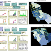
An Agent-based Assessment of Health Vulnerability to Long-term particulate exposure in Seoul Districts
Hyesop Shin Mike Bithell | Published Monday, November 05, 2018 | Last modified Monday, December 03, 2018This model aims to understand the cumulative effects on the population’s vulnerability as represented by exposure to PM10 (particulate matter with diameter less than 10 micrometres) by different age and educational groups in two Seoul districts, Gangnam and Gwanak. Using this model, readers can explore individual’s daily commuting routine, and its health loss when the PM10 concentration of the current patch breaches the national limit of 100µg/m3.
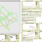
Simulation of the Governance of Complex Systems
Fabian Adelt Johannes Weyer Robin D Fink Andreas Ihrig | Published Monday, December 18, 2017 | Last modified Friday, March 02, 2018Simulation-Framework to study the governance of complex, network-like sociotechnical systems by means of ABM. Agents’ behaviour is based on a sociological model of action. A set of basic governance mechanisms helps to conduct first experiments.
Lakeland 2 is a simple version of the original Lakeland of Jager et al. (2000) Ecological Economics 35(3): 357-380. The model can be used to explore the consequences of different behavioral assumptions on resource and social dynamics.

Eixample-MAS Traffic Simulation
Àlex Pardo Fernandez David Sánchez Pinsach | Published Tuesday, January 22, 2013 | Last modified Saturday, April 27, 2013This MAS simulates the traffic of Barcelona Eixample. Uses a centralized AI system in order to control the traffic lights. Car agents are reactive and have no awareness of the intelligence of the system. They (try to) avoid collisions.