Our mission is to help computational modelers develop, document, and share their computational models in accordance with community standards and good open science and software engineering practices. Model authors can publish their model source code in the Computational Model Library with narrative documentation as well as metadata that supports open science and emerging norms that facilitate software citation, computational reproducibility / frictionless reuse, and interoperability. Model authors can also request private peer review of their computational models. Models that pass peer review receive a DOI once published.
All users of models published in the library must cite model authors when they use and benefit from their code.
Please check out our model publishing tutorial and feel free to contact us if you have any questions or concerns about publishing your model(s) in the Computational Model Library.
Displaying 10 of 95 results landscape clear search
From Boundary Crossings to Global Connectivity: A Minimal Mechanism in Structured Agent-Based Landscapes
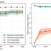
Fabio Nelli | Published Sunday, May 17, 2026This repository contains the Python implementation of an agent-based model investigating how localized boundary-crossing dynamics generate large-scale connectivity in structured multi-attractor landscapes.
Agents evolve in a continuous two-dimensional environment composed of attractor basins. A fraction of agents exhibits exploratory higher-mobility dynamics, while the remaining agents remain locally constrained. The model analyzes how localized configurational transitions accumulate into transition networks that progressively integrate the explored state space.
The repository includes:
…
Peer reviewed Gradient Descent Simulation
Ilyes Azouani | Published Wednesday, March 18, 2026 | Last modified Monday, May 25, 2026This model visualizes gradient descent optimization - the fundamental algorithm used to train neural networks and other machine learning models. Agents represent different optimization algorithms searching for the minimum of a loss landscape (the “error surface” that ML models try to minimize during training).
The model demonstrates how different optimizer types (SGD, Momentum with different parameters) behave on various loss landscapes, from simple bowls to the notoriously difficult Rosenbrock “banana valley” function. This helps build intuition about why certain optimization algorithms work better than others for different problem geometries.
HOW IT WORKS
…
Agent-based Modelling of Unsustainable and Sustainable Norms Under Resource Constraints
Fachrizal Sinaga Adrian Thomas Sufyan Fawwad | Published Monday, November 24, 2025This model explores the coupled dynamics of social norm diffusion and finite resource depletion. Extending the “Affordance Landscape” framework by Kaaronen & Strelkovskii (2020), this simulation investigates how resource scarcity and regeneration rates influence the adoption of pro-environmental behaviours.
The model addresses the gap by linking behavioural norms to a depleting common-pool resource. It tests whether sustainable norms can diffuse rapidly enough to prevent ecological collapse and identifies “tipping points” where resource scarcity acts as a driver for behavioural change.
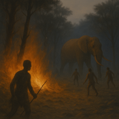
Peer reviewed HUMLAND FIRE-IN-THE-HOLE agent-based model
Fulco Scherjon Anastasia Nikulina | Published Monday, October 20, 2025HUMLAND Fire-in-the-Hole is a conceptual agent-based model (ABM) designed to explore the ecological and behavioral consequences of fire-driven hunting strategies employed by hunter-gatherers, specifically Neanderthals, during the Last Interglacial period around the Neumark-Nord (Germany) archaeological site.
This model builds on and specializes the HUMLAND 1.0.0 model (Nikulina et al. 2024), integrating anthropogenic fires, elephant group behavior, and landscape response to simulate interactions between humans, megafauna, and vegetation over time.
An agent-based model exploring the biodiversity-agriculture-nutrition dynamics in Eastern Madagascar resulting from alternative land uses
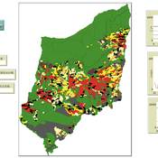
Romain Clercq-Roques Jessica Williams Katja Perez Guzman Marta Kozicka Kristine Belesova Zaid Chalabi | Published Wednesday, July 23, 2025This agent-based model simulates the interactions between smallholder farming households, land-use dynamics, and ecosystem services in a rural landscape of Eastern Madagascar. It explores how alternative agricultural practices —shifting agriculture, rice cultivation, and agroforestry—combined with varying levels of forest protection, influence food production, food security, dietary diversity, and forest biodiversity over time. The landscape is represented as a grid of spatially explicit patches characterized by land use, ecological attributes, and regeneration dynamics. Agents make yearly decisions on land management based on demographic pressures, agricultural returns, and institutional constraints. Crop yields are affected by stochastic biotic and abiotic disruptions, modulated by local ecosystem regulation functions. The model additionally represents foraging as a secondary food source and pressure on biodiversity. The model supports the analysis of long-term trade-offs between agricultural productivity, human nutrition, and conservation under different policy and land-use scenarios.
The SAFIRe model : Simulation of Agents for Fertility, Integrated Energy, Food security, and Reforestation
Etienne DELAY Lucas Broutin | Published Thursday, June 12, 2025The SAFIRe model (Simulation of Agents for Fertility, Integrated Energy, Food Security, and Reforestation) is an agent-based model co-developed with rural communities in Senegal’s Groundnut Basin. Its purpose is to explore how local farming and pastoral practices affect the regeneration of Faidherbia albida trees, which are essential for maintaining soil fertility and supporting food security through improved millet production. The model supports collective reflection on how different social and ecological factors interact, particularly around firewood demand, livestock pressure, and agricultural intensification.
The model simulates a 100-hectare agricultural landscape where agents (farmers, shepherds, woodcutters, and supervisors) interact with trees, land parcels, and each other. It incorporates seasonality, crop rotation, tree growth and cutting, livestock feeding behaviors, and farmers’ engagement in sapling protection through Assisted Natural Regeneration (ANR). Two types of surveillance strategies are compared: community-led monitoring and delegated surveillance by forestry authorities. Farmer engagement evolves over time based on peer influence, meeting participation, and the success of visible tree regeneration efforts.
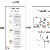
SAFIRe integrates participatory modeling (ComMod and ComExp) and a backcasting approach (ACARDI) to co-produce scenarios rooted in local aspirations. It was explored using the OpenMole platform, allowing stakeholders to test a wide range of future trajectories and analyze the sensitivity of key parameters (e.g., discussion frequency, time in fields). The model’s outcomes not only revealed unexpected insights—such as the hidden role of farmers in tree loss—but also led to real-world actions, including community nursery creation and behavioral shifts toward tree care. SAFIRe illustrates how agent-based modeling can become a tool for social learning and collective action in socio-ecological systems.
Peer reviewed soslivestock model
Marco Janssen Irene Perez Ibarra Diego J. Soler-Navarro Alicia Tenza Peral | Published Wednesday, May 28, 2025 | Last modified Tuesday, June 10, 2025The purpose of this model is to analyze how different management strategies affect the wellbeing, sustainability and resilience of an extensive livestock system under scenarios of climate change and landscape configurations. For this purpose, it simulates one cattle farming system, in which agents (cattle) move through the space using resources (grass). Three farmer profiles are considered: 1) a subsistence farmer that emphasizes self-sufficiency and low costs with limited attention to herd management practices, 2) a commercial farmer focused on profit maximization through efficient production methods, and 3) an environmental farmer that prioritizes conservation of natural resources and animal welfare over profit maximization. These three farmer profiles share the same management strategies to adapt to climate and resource conditions, but differ in their goals and decision-making criteria for when, how, and whether to implement those strategies. This model is based on the SequiaBasalto model (Dieguez Cameroni et al. 2012, 2014, Bommel et al. 2014 and Morales et al. 2015), replicated in NetLogo by Soler-Navarro et al. (2023).
One year is 368 days. Seasons change every 92 days. Each step begins with the growth of grass as a function of climate and season. This is followed by updating the live weight of animals according to the grass height of their patch, and grass consumption, which is determined based on the updated live weight. Animals can be supplemented by the farmer in case of severe drought. After consumption, cows grow and reproduce, and a new grass height is calculated. This updated grass height value becomes the starting grass height for the next day. Cows then move to the next area with the highest grass height. After that, cattle prices are updated and cattle sales are held on the first day of fall. In the event of a severe drought, special sales are held. Finally, at the end of the day, the farm balance and the farmer’s effort are calculated.
Multi-Agent Socio-Ecological Hani Terrace Model
Lei Dong Yunnan University | Published Saturday, March 29, 2025This model is to explore the changes of paddy field landscape and household livelihood structure in the village under different policy scenarios, evaluate the eco-social effects of different policies, and provide decision support tools for proposing effective and feasible policies.
MIXTRUST - crop-livestock interactions at regional level
Myriam Grillot Aurélien Peter | Published Tuesday, February 25, 2025 | Last modified Monday, September 01, 2025The basic idea behind developing MIXTRUST was to represent a network of agricultural stakeholders composed of farmers and a cooperative in a mixed landscape to test its performances in response to risks. A mixed landscape here is a landscape where crop and livestock systems interact by the intermediary of material flows of agricultural products. It can be within mixed farms, or between farms, often specialized, (e.g. straw-manure).
Shellmound Mobility
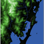
Henrique de Sena Kozlowski | Published Saturday, June 15, 2024Least Cost Path (LCP) analysis is a recurrent theme in spatial archaeology. Based on a cost of movement image, the user can interpret how difficult it is to travel around in a landscape. This kind of analysis frequently uses GIS tools to assess different landscapes. This model incorporates some aspects of the LCP analysis based on GIS with the capabilities of agent-based modeling, such as the possibility to simulate random behavior when moving. In this model the agent will travel around the coastal landscape of Southern Brazil, assessing its path based on the different cost of travel through the patches. The agents represent shellmound builders (sambaquieiros), who will travel mainly through the use of canoes around the lagoons.
How it works?
When the simulation starts the hiker agent moves around the world, a representation of the lagoon landscape of the Santa Catarina state in Southern Brazil. The agent movement is based on the travel cost of each patch. This travel cost is taken from a cost surface raster created in ArcMap to represent the different cost of movement around the landscape. Each tick the agent will have a chance to select the best possible patch to move in its Field of View (FOV) that will take it towards its target destination. If it doesn’t select the best possible patch, it will randomly choose one of the patches to move in its FOV. The simulation stops when the hiker agent reaches the target destination. The elevation raster file and the cost surface map are based on a 1 Arc-second (30m) resolution SRTM image, scaled down 5 times. Each patch represents a square of 150m, with an area of 0,0225km². The dataset uses a UTM Sirgas 2000 22S projection system. There are four different cost functions available to use. They change the cost surface used by the hikers to navigate around the world.
Displaying 10 of 95 results landscape clear search