About the CoMSES Model Library more info
Our mission is to help computational modelers at all levels engage in the establishment and adoption of community standards and good practices for developing and sharing computational models. Model authors can freely publish their model source code in the Computational Model Library alongside narrative documentation, open science metadata, and other emerging open science norms that facilitate software citation, reproducibility, interoperability, and reuse. Model authors can also request peer review of their computational models to receive a DOI.
All users of models published in the library must cite model authors when they use and benefit from their code.
Please check out our model publishing tutorial and contact us if you have any questions or concerns about publishing your model(s) in the Computational Model Library.
We also maintain a curated database of over 7500 publications of agent-based and individual based models with additional detailed metadata on availability of code and bibliometric information on the landscape of ABM/IBM publications that we welcome you to explore.
Displaying 10 of 35 results spatially explicit clear search
Peer reviewed CHIME ABM Hurricane Evacuation Model
Joshua Watts | Published Friday, March 03, 2017 | Last modified Wednesday, May 29, 2019The CHIME ABM explores information distribution networks and agents’ protective decision making in the context of hurricane landfall.
An agent-based approach to weighted decision making in the spatially and temporally variable South African Paleoscape
Colin Wren | Published Thursday, December 29, 2016This model simulates a foraging system based on Middle Stone Age plant and shellfish foraging in South Africa.
TREELIM
Gudrun Wallentin | Published Wednesday, November 30, 2016 | Last modified Tuesday, January 10, 2017The model simulates the spatial patterns of secondary forest succession above the current alpine tree line in the context of land use and climate change. Three scenarios are offered: (1) climate change, (2) land use change, (3) species composition.
Hybrid fish-plankton model
Gudrun Wallentin Christian Neuwirth | Published Friday, October 28, 2016 | Last modified Sunday, January 29, 2017A hybrid predator-prey model of fish and plankton that switches dynamically between ABM and SD representations. It contains 6 related structural designs of the same model.
Stylized agricultural land-use model for resilience exploration
Patrick Bitterman | Published Tuesday, June 14, 2016 | Last modified Monday, April 08, 2019This model is a highly stylized land use model in the Clear Creek Watershed in Eastern Iowa, designed to illustrate the construction of stability landscapes within resilience theory.
Central-place forager mobility and cultural diversity
Luke Premo | Published Wednesday, May 18, 2016This spatially explicit agent-based model addresses how effective foraging radius (r_e) affects the effective size–and thus the equilibrium cultural diversity–of a structured population composed of central-place foraging groups.
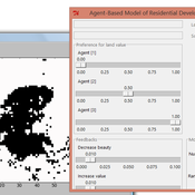
IDEAL
Arika Ligmann-Zielinska | Published Thursday, August 07, 2014IDEAL: Agent-Based Model of Residential Land Use Change where the choice of new residential development in based on the Ideal-point decision rule.
Informal City version 1.0
Nina Schwarz | Published Friday, July 25, 2014 | Last modified Thursday, July 30, 2015InformalCity, a spatially explicit agent-based model, simulates an artificial city and allows for testing configurations of urban upgrading schemes in informal settlements.
Land Use in the Chitwan Valley
Alex Zvoleff | Published Monday, June 02, 2014chitwanabm is a spatially explicit agent-based model of population and land use in the Chitwan Valley, Nepal, designed to explore feedbacks between population and environment, with a heavy focus on community context and individual-level variation.
Concession Forestry Modeling
Andrew Bell Daniel G Brown Rick L Riolo Jacqueline M Doremus Thomas P Lyon John Vandermeer Arun Agrawal | Published Thursday, January 23, 2014A logging agent builds roads based on the location of high-value hotspots, and cuts trees based on road access. A forest monitor sanctions the logger on observed infractions, reshaping the pattern of road development.
Displaying 10 of 35 results spatially explicit clear search