Our mission is to help computational modelers develop, document, and share their computational models in accordance with community standards and good open science and software engineering practices. Model authors can publish their model source code in the Computational Model Library with narrative documentation as well as metadata that supports open science and emerging norms that facilitate software citation, computational reproducibility / frictionless reuse, and interoperability. Model authors can also request private peer review of their computational models. Models that pass peer review receive a DOI once published.
All users of models published in the library must cite model authors when they use and benefit from their code.
Please check out our model publishing tutorial and feel free to contact us if you have any questions or concerns about publishing your model(s) in the Computational Model Library.
Displaying 10 of 195 results decision clear search
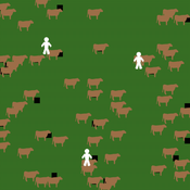
MASTOC-LLM (Multi-Agent System Tragedy of the Commons - Large Language Models)
Thomas Tuoti | Published Monday, May 18, 2026 | Last modified Tuesday, May 19, 2026MASTOC-LLM extends the classic Multi-Agent System Tragedy of the Commons (MASTOC) model by replacing hard-coded behavioral rules with autonomous decision-making powered by large language models (LLMs). Three heterogeneous agents manage herds of cows on a shared grassland commons. Each tick, an agent receives a structured prompt describing current resource levels, its own herd size, peer behavior, and — optionally — a rolling memory of recent rounds and messages from neighboring agents. The LLM returns a stocking decision (add, remove, or hold cows) together with a natural-language rationale and, when communication is enabled, a short message to broadcast to peers.
The model is designed to test whether LLM agents spontaneously develop Ostrom-style common-pool resource governance (mutual monitoring, graduated sanctions, graduated rule revision) or instead fall into identifiable failure modes. Preliminary experiments with Claude Haiku 4.5, GPT-5.4-mini, and DeepSeek R1:32b have revealed four recurring collapse patterns — Cooperative Paralysis, Defection Cascade, Overshoot-Panic, and Hybrid Architecture Failure — whose onset timing is sensitive to memory length, inter-agent communication, and the post-training alignment approach of the underlying model.
MASTOC-LLM is intended as a laboratory for generative agent-based modelling (GABM) methodology: it provides a clean, well-understood commons baseline against which LLM behavioral hypotheses can be systematically tested and compared across models, parameter sweeps, and alignment regimes.
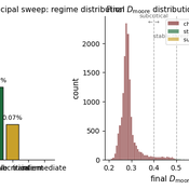
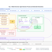
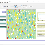
The Informational Assumptions of Schelling Segregation: An Agent-Based Decomposition of Cue Inference, Cultural Schemas, and Residential Sorting
Eric Gladstone | Published Wednesday, May 13, 2026This computational model accompanies the article “The Informational Assumptions of Schelling Segregation: An Agent-Based Decomposition of Cue Inference, Cultural Schemas, and Residential Sorting.” It implements an agent-based model in which agents infer latent neighborhood-type classes from noisy non-demographic cues through schema-specific diagnostic mappings, update beliefs, and relocate when satisfaction on a preferred latent class falls below a threshold.
The model serves as a mechanism-isolation device for studying the informational architecture underlying Schelling-style residential sorting. It includes the principal sweep configuration (14,400 runs across a seven-parameter grid), a disagreement-metric sub-sweep with permutation-minimized Jensen-Shannon divergence recorded natively, controls (positive, negative, and frozen-belief), a paired-seed cue-channel perturbation experiment, and selected-cell sensitivity sweeps for cue persistence and home-biased mobility.
The full ODD protocol, parameter manifests, deterministic seed schedules, processed outputs, regenerable figure scripts, the verification test suite, and the satisfaction-mapping audit document are included. Every reported run is deterministic given a (config, seed) pair, and an included audit script verifies bit-for-bit replay on sampled runs.
Peer reviewed Kenya ITN Agent-Based Microsimulation (2003–2024)
Wooyoung Kim Hosang Shin | Published Saturday, April 18, 2026 | Last modified Tuesday, June 16, 2026An agent-based microsimulation of insecticide-treated net (ITN) distribution and adoption in Kenya (2003–2024), integrating the Theory of Planned Behaviour, Rogers diffusion, Weibull net decay, and a GPS-based two-layer social network. 8,561 household agents calibrated via Approximate Bayesian Computation to six DHS/MIS survey waves, achieving 2.42 pp mean absolute error on Kenya-level ownership. The analysis chain supports mechanism counterfactuals and policy experiments on equity outcomes of ITN distribution strategies.
Exploring the aftermath of transition failures: An agent-based model
Gangmin Park Junmin Lee Jisoo Lee Keungoui Kim | Published Friday, March 06, 2026This computational model is an agent-based model (ABM) developed to investigate how repeated failures of emerging niches accumulate and influence the trajectory of socio-technical transitions. Built in AnyLogic 8.7.11, the model simulates the dynamic interactions between a dominant regime and sequential niche entrants within a two-dimensional practice space. It models alignment, movement, and competition based on technological maturity and market penetration. The model utilizes a reinforcing feedback structure linking consumer support, output, resource accumulation, and capacity development (Physical and Institutional Capacity). A complete model specification following the ODD+D (Overview, Design concepts, Details, and Decision) protocol is included in the documentation.
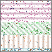
Peer reviewed The Andean Resource Management Model (ARMM)
Olga Palacios | Published Tuesday, January 20, 2026ARMM is a theoretical agent-based model that formalizes Murra’s Theory of Verticality (Murra, 1972) to explore how multi-zonal resource management systems emerge in mountain landscapes. The model identifies the social, political, and economic mechanisms that enable vertical complementarity across ecological gradients.
Built in NetLogo, ARMM employs an abstract 111×111 grid divided into four Andean ecological zones (Altiplano, Highland, Lowland, Coast), each containing up to 18 resource types distributed according to ecological suitability. To test general theoretical principles rather than replicate specific geography, resource locations are randomized at each model initialization.
Settlement agents pursue one of two economic strategies: diversification (seeking resource variety, maximum 2 units per type) or accumulation (maximising total quantity, maximum 30 units). Agents move between adjacent zones through hierarchical decision-making, first attempting peaceful interactions—coexistence (governed by tolerance) and trading (governed by cooperation)—before resorting to conflict (theft or takeover, governed by belligerence).
The model demonstrates that vertical complementarity can emerge through fundamentally different mechanisms: either through autonomous mobility under political decentralization or through state-coordinated redistribution under centralization. Sensitivity analysis reveals that belligerence and economic strategy explain approximately 25% of outcome variance, confirming that structural inequalities between zones result from political-economic organization rather than environmental constraints alone.
As a preliminary theoretical model, ARMM intentionally maintains simplicity to isolate core mechanisms and generate testable hypotheses. This foundational framework will guide future empirically-calibrated versions that incorporate specific archaeological settlement data and geographic features from the Carangas region (Bolivia-Chile border), enabling direct comparison between theoretical predictions and observed historical patterns.
FRAMe (Flood Resilience Agent-Based Model)
Wenhan Feng | Published Wednesday, October 22, 2025The FRAMe (Flood Resilience Agent-Based Model) serves as a framework designed to simulate flood resilience dynamics at the community level, focusing on a rural settlement in the Mekong River Basin. Integrating empirical data from extensive surveys, Bayesian networks, and hydrological simulations, the framework quantifies resilience as a trade-off between robustness (resistance to damage) and adaptability (capacity for dynamic response). Agents include households, governments, and other actors, linked by social and governance networks that facilitate knowledge transfer, resource distribution, and risk communication. FRAMe incorporates mechanisms for flood forecasting, policy interventions (education, aid, insurance), and individual and collective decision-making, grounded in Protection Motivation Theory and MoHuB frameworks. The framework’s spatially explicit design leverages GIS data, which supports scenario testing of governance structures and stakeholder interactions. By examining policy scenarios and agent behavior, FRAMe aims to inform adaptive flood management strategies and enhance community resilience.
Peer reviewed E³-MAN. An Institutionally-guided multi-agent. Model for fair and efficient negotiation.
José luis bustelo | Published Monday, September 01, 2025Negotiation plays a fundamental role in shaping human societies, underpinning conflict resolution, institutional design, and economic coordination. This article introduces E³-MAN, a novel multi-agent model for negotiation that integrates individual utility maximization with fairness and institutional legitimacy. Unlike classical approaches grounded solely in game theory, our model incorporates Bayesian opponent modeling, transfer learning from past negotiation domains, and fallback institutional rules to resolve deadlocks. Agents interact in dynamic environments characterized by strategic heterogeneity and asymmetric information, negotiating over multidimensional issues under time constraints. Through extensive simulation experiments, we compare E³-MAN against the Nash bargaining solution and equal-split baselines using key performance metrics: utilitarian efficiency, Nash social welfare, Jain fairness index, Gini coefficient, and institutional compliance. Results show that E³-MAN achieves near-optimal efficiency while significantly improving distributive equity and agreement stability. A legal application simulating multilateral labor arbitration demonstrates that institutional default rules foster more balanced outcomes and increase negotiation success rates from 58% to 98%. By combining computational intelligence with normative constraints, this work contributes to the growing field of socially aware autonomous agents. It offers a virtual laboratory for exploring how simple institutional interventions can enhance justice, cooperation, and robustness in complex socio-legal systems.
An Agent-Based Model of Farmland Trading Partners Selection
Hang Xiong Chen Yuxin Xinfan Wang | Published Tuesday, August 19, 2025This base model uses an agent-based approach to represent heterogeneous farmers’ trading partners selection among multiple recipients (other farmers, village collectives, and firms). Each period, a potential transfer-out farmer decides whether to transfer based on a net-return versus transaction-cost trade-off; if transferring, the farmer selects the counterparty with the highest expected profit. Meanwhile, social learning—operationalized as logistic accumulation of neighborhood experience—continuously updates uncertainty, which in turn shapes transaction costs and subsequent decisions.
An agent-based model of the journey of victim/survivors through local authority domestic abuse support services in the UK
Bruce Edmonds | Published Monday, July 28, 2025This model played a small part in the UK government’s review of the working of local authority implementation of the Domestic Abuse legislation. The model explicitly represents victim-survivor families as they: (a) try to contact the local DA support system, (b) are triaged by the system and (if there is space) allocated to safe temporary accomodation (c) recieve support services from this position and (d) eventually move on to more permenant accomodation. The purpose of the model was to understand some possible ways in which the implementation of DA Duty, might be frustrated in practice, the identification of gaps in the evidence base and to inform the developing Theory of Change. The key measures used for assessing outcomes in the model were the number of families helped and the services that were delivered to them. The exploration was grounded for in two archetypal cases: that of a relatively immature system for the delivery of DA services and a more mature one (based on actual local authority cases, but not based on any single one). See the official report under associated publications for a summary of results.

BESTMAP-ABM-DE is an agent-based model to determine the adoption and spatial allocation of selected agri-environmental schemes (AES) by individual farmers in the Mulde River Basin located in Western Saxony, Germany. The selected AES are buffer areas, cover crops, maintaining permanent grassland and conversion of arable land to permanent grassland. While the first three schemes have already been offered in the case study area, the latter scheme is a hypothetical scheme designed to test the impact of potential policy changes. For the first model analyses, only the currently offered schemes are considered. With the model, the effect of different scenarios of policy design on patterns of adoption can be investigated. In particular, the model can be used to study the social-ecological consequences of agricultural policies at different spatial and temporal scales and, in combination with biophysical models, test the ecological implications of different designs of the EU’s Common Agricultural Policy. The model was developed in the BESTMAP project.
Displaying 10 of 195 results decision clear search