Our mission is to help computational modelers develop, document, and share their computational models in accordance with community standards and good open science and software engineering practices. Model authors can publish their model source code in the Computational Model Library with narrative documentation as well as metadata that supports open science and emerging norms that facilitate software citation, computational reproducibility / frictionless reuse, and interoperability. Model authors can also request private peer review of their computational models. Models that pass peer review receive a DOI once published.
All users of models published in the library must cite model authors when they use and benefit from their code.
Please check out our model publishing tutorial and feel free to contact us if you have any questions or concerns about publishing your model(s) in the Computational Model Library.
Displaying 10 of 49 results Adaptation clear search
The Internal Organizational Plasticity Model (IOP 2.1.2)
Davide Secchi | Published Tuesday, June 02, 2020IOP 2.1.2 is an agent-based simulation model designed to explore the relations between (1) employees, (2) tasks and (3) resources in an organizational setting. By comparing alternative cognitive strategies in the use of resources, employees face increasingly demanding waves of tasks that derive by challenges the organization face to adapt to a turbulent environment. The assumption tested by this model is that a successful organizational adaptation, called plastic, is necessarily tied to how employees handle pressure coming from existing and new tasks. By comparing alternative cognitive strategies, connected to ‘docility’ (Simon, 1993; Secchi, 2011) and ‘extended’ cognition (Clark, 2003, Secchi & Cowley, 2018), IOP 2.1.2 is an attempt to indicate which strategy is most suitable and under which scenario.
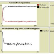
Market-level effects of firm-level adaptation and intermediation in networked markets of fresh foods: a case study in Colombia.
César García-Díaz | Published Sunday, April 12, 2020 | Last modified Sunday, April 12, 2020This a model developed as a part of the paper Mejía, G. & García-Díaz, C. (2018). Market-level effects of firm-level adaptation and intermediation in networked markets of fresh foods: a case study in Colombia. Agricultural Systems 160: 132-142.
It simulates the competition dynamics of the potato market in Bogotá, Colombia. The model explores the economic impact of intermediary actors on the potato supply chain.
PoliSEA: model of Policy – Social Ecological system Adaptation
Maja Schlüter Kirill Orach | Published Thursday, March 26, 2020PoliSEA represents a continuous policy process cycle, integrated with the dynamics of a fishery social-ecological system. The policy process in the model is represented by interactions between policymakers and interest groups and subsequent voting during which policymaker decide to increase or decrease the fishing quota for the next season. Policymakers’ positions can be influenced by lobbying of interest groups or interest group coalitions. The quota adopted through the policy process determines the amount of fish that can be harvested from the fish population during the season.
Peer reviewed Flibs'NLogo - An elementary form of evolutionary cognition
Cosimo Leuci | Published Thursday, January 30, 2020 | Last modified Monday, June 15, 2026Flibs’NLogo is an agent-based simulation implemented in NetLogo that models the evolution of perfect predictors through a genetic algorithm. The agents, called flibs (finite living blobs), are finite‑state automata whose behaviour is encoded in circular chromosomes. They inhabit a “primordial computer soup” and are tasked with anticipating a user‑defined periodic binary sequence. Each generation consists of 100 evaluation cycles, during which a flib’s fitness is incremented each time its output correctly matches the next environmental signal.
Reproduction follows an elitist scheme: a donor (current fittest individual) replaces a randomly chosen recipient either by cloning (complete genome substitution) or by bacterial‑like conjugation (unidirectional horizontal transfer of a random chromosome segment). A stochastic mutagenesis operator introduces point mutations in genes, while the reproductive strategy gene can also switch under a mixed-reproduction regime. Population dynamics are monitored via genomic diversity indices (Shannon‑Wiener, Simpson), a phenotypic simpleness metric that distinguishes the low number of states actually used from the genomic potential.
The model serves as a digital evolutionary laboratory for exploring the interplay among bounded rationality, collective adaptation, and the emergence of anticipatory behaviour. By linking evolutionary computation with cognitive concepts, Flibs’NLogo investigates fundamental transitions from reactive to predictive systems and allows for testing whether populations evolve toward minimal necessary complexity or exhibit an intrinsic drift toward structural elaboration.
Peer reviewed BAM: The Bottom-up Adaptive Macroeconomics Model
Alejandro Platas López Alejandro Guerra-Hernández | Published Tuesday, January 14, 2020 | Last modified Sunday, July 26, 2020Overview
Purpose
Modeling an economy with stable macro signals, that works as a benchmark for studying the effects of the agent activities, e.g. extortion, at the service of the elaboration of public policies..
…
A network agent-based model of ethnocentrism and intergroup cooperation
Ross Gore | Published Sunday, October 27, 2019We present a network agent-based model of ethnocentrism and intergroup cooperation in which agents from two groups (majority and minority) change their communality (feeling of group solidarity), cooperation strategy and social ties, depending on a barrier of “likeness” (affinity). Our purpose was to study the model’s capability for describing how the mechanisms of preexisting markers (or “tags”) that can work as cues for inducing in-group bias, imitation, and reaction to non-cooperating agents, lead to ethnocentrism or intergroup cooperation and influence the formation of the network of mixed ties between agents of different groups. We explored the model’s behavior via four experiments in which we studied the combined effects of “likeness,” relative size of the minority group, degree of connectivity of the social network, game difficulty (strength) and relative frequencies of strategy revision and structural adaptation. The parameters that have a stronger influence on the emerging dominant strategies and the formation of mixed ties in the social network are the group-tag barrier, the frequency with which agents react to adverse partners, and the game difficulty. The relative size of the minority group also plays a role in increasing the percentage of mixed ties in the social network. This is consistent with the intergroup ties being dependent on the “arena” of contact (with progressively stronger barriers from e.g. workmates to close relatives), and with measures that hinder intergroup contact also hindering mutual cooperation.
Peer reviewed lgm_ecodynamics
Colin Wren | Published Monday, April 22, 2019This is a modification of a model published previous by Barton and Riel-Salvatore (2012). In this model, we simulate six regional populations within Last Glacial Maximum western Europe. Agents interact through reproduction and genetic markers attached to each of six regions mix through subsequent generations as a way to track population dynamics, mobility, and gene flow. In addition, the landscape is heterogeneous and affects agent mobility and, under certain scenarios, their odds of survival.
Risks and Hedonics in Empirical Agent-based land market (RHEA) model
Tatiana Filatova Koen de Koning | Published Monday, April 01, 2019RHEA aims to provide a methodological platform to simulate the aggregated impact of households’ residential location choice and dynamic risk perceptions in response to flooding on urban land markets. It integrates adaptive behaviour into the spatial landscape using behavioural theories and empirical data sources. The platform can be used to assess: how changes in households’ preferences or risk perceptions capitalize in property values, how price dynamics in the housing market affect spatial demographics in hazard-prone urban areas, how structural non-marginal shifts in land markets emerge from the bottom up, and how economic land use systems react to climate change. RHEA allows direct modelling of interactions of many heterogeneous agents in a land market over a heterogeneous spatial landscape. As other ABMs of markets it helps to understand how aggregated patterns and economic indices result from many individual interactions of economic agents.
The model could be used by scientists to explore the impact of climate change and increased flood risk on urban resilience, and the effect of various behavioural assumptions on the choices that people make in response to flood risk. It can be used by policy-makers to explore the aggregated impact of climate adaptation policies aimed at minimizing flood damages and the social costs of flood risk.
MEGADAPT - Socio-hydrological risk model - Theoretical (no data) implementation
Marco Janssen Andres Baeza-Castro Luis Bojorquez Hallie Eakin | Published Wednesday, February 06, 2019The model simulates the decisions of residents and a water authority to respond to socio-hydrological hazards. Residents from neighborhoods are located in a landscape with topographic complexity and two problems: water scarcity in the peripheral neighborhoods at high altitude and high risk of flooding in the lowlands, at the core of the city. The role of the water authority is to decide where investments in infrastructure should be allocated to reduce the risk to water scarcity and flooding events in the city, and these decisions are made via a multi-objective site selection procedure. This procedure accounts for the interdependencies and feedback between the urban landscape and a policy scenario that defines the importance, or priorities, that the authority places on four criteria.
Neighborhoods respond to the water authority decisions by protesting against the lack of investment and the level of exposure to water scarcity and flooding. Protests thus simulate a form of feedback between local-level outcomes (flooding and water scarcity) and higher-level decision-making. Neighborhoods at high altitude are more likely to be exposed to water scarcity and lack infrastructure, whereas neighborhoods in the lowlands tend to suffer from recurrent flooding. The frequency of flooding is also a function of spatially uniform rainfall events. Likewise, neighborhoods at the periphery of the urban landscape lack infrastructure and suffer from chronic risk of water scarcity.
The model simulates the coupling between the decision-making processes of institutional actors, socio-political processes and infrastructure-related hazards. In the documentation, we describe details of the implementation in NetLogo, the description of the procedures, scheduling, and the initial conditions of the landscape and the neighborhoods.
This work was supported by the National Science Foundation under Grant No. 1414052, CNH: The Dynamics of Multi-Scalar Adaptation in Megacities (PI Hallie Eakin).
Peer reviewed MigrAgent
Wander Jager Rocco Paolillo | Published Friday, October 05, 2018 | Last modified Wednesday, November 28, 2018MigrAgent simulates migration flows of a population from a home country to a host country and mutual adaptation of a migrant and local population post-migration. Agents accept interactions in intercultural networks depending on their degree of conservatism. Conservatism is a group-level parameter normally distributed within each ethnic group. Individual conservatism changes as function of reciprocity of interaction in intergroup experiences of acceptance or rejection.
The aim of MigrAgent is to unfold different outcomes of integration, assimilation, separation and marginalization in terms of networks as effect of different degrees of conservatism in each group and speed of migration flows.
Displaying 10 of 49 results Adaptation clear search