Our mission is to help computational modelers develop, document, and share their computational models in accordance with community standards and good open science and software engineering practices. Model authors can publish their model source code in the Computational Model Library with narrative documentation as well as metadata that supports open science and emerging norms that facilitate software citation, computational reproducibility / frictionless reuse, and interoperability. Model authors can also request private peer review of their computational models. Models that pass peer review receive a DOI once published.
All users of models published in the library must cite model authors when they use and benefit from their code.
Please check out our model publishing tutorial and feel free to contact us if you have any questions or concerns about publishing your model(s) in the Computational Model Library.
Displaying 10 of 501 results from clear search
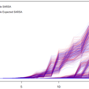
Space colonization
allagonne | Published Wednesday, January 05, 2022Agent-Based-Modeling - space colonization
ask me for the .nlogo model
WHAT IS IT?
The goal of this project is to simulate with NetLogo (v6.2) a space colonization of humans, starting from Earth, into the Milky Way.
HOW IT WORKS
…
Peer reviewed Labor and environment in global value chains: An evolutionary policy study with a three-sector and two-region agent-based macroeconomic model
Lena Gerdes Manuel Scholz-Wäckerle Bernhard Rengs | Published Wednesday, December 22, 2021With this model, we investigate resource extraction and labor conditions in the Global South as well as implications for climate change originating from industry emissions in the North. The model serves as a testbed for simulation experiments with evolutionary political economic policies addressing these issues. In the model, heterogeneous agents interact in a self-organizing and endogenously developing economy. The economy contains two distinct regions – an abstract Global South and Global North. There are three interlinked sectors, the consumption good–, capital good–, and resource production sector. Each region contains an independent consumption good sector, with domestic demand for final goods. They produce a fictitious consumption good basket, and sell it to the households in the respective region. The other sectors are only present in one region. The capital good sector is only found in the Global North, meaning capital goods (i.e. machines) are exclusively produced there, but are traded to the foreign as well as the domestic market as an intermediary. For the production of machines, the capital good firms need labor, machines themselves and resources. The resource production sector, on the other hand, is only located in the Global South. Mines extract resources and export them to the capital firms in the North. For the extraction of resources, the mines need labor and machines. In all three sectors, prices, wages, number of workers and physical capital of the firms develop independently throughout the simulation. To test policies, an international institution is introduced sanctioning the polluting extractivist sector in the Global South as well as the emitting industrial capital good producers in the North with the aim of subsidizing innovation reducing environmental and social impacts.
An ABM of historic British milk consumption
Matthew Gibson | Published Monday, December 20, 2021Substitution of food products will be key to realising widespread adoption of sustainable diets. We present an agent-based model of decision-making and influences on food choice, and apply it to historically observed trends of British whole and skimmed (including semi) milk consumption from 1974 to 2005. We aim to give a plausible representation of milk choice substitution, and test different mechanisms of choice consideration. Agents are consumers that perceive information regarding the two milk choices, and hold values that inform their position on the health and environmental impact of those choices. Habit, social influence and post-decision evaluation are modelled. Representative survey data on human values and long-running public concerns empirically inform the model. An experiment was run to compare two model variants by how they perform in reproducing these trends. This was measured by recording mean weekly milk consumption per person. The variants differed in how agents became disposed to consider alternative milk choices. One followed a threshold approach, the other was probability based. All other model aspects remained unchanged. An optimisation exercise via an evolutionary algorithm was used to calibrate the model variants independently to observed data. Following calibration, uncertainty and global variance-based temporal sensitivity analysis were conducted. Both model variants were able to reproduce the general pattern of historical milk consumption, however, the probability-based approach gave a closer fit to the observed data, but over a wider range of uncertainty. This responds to, and further highlights, the need for research that looks at, and compares, different models of human decision-making in agent-based and simulation models. This study is the first to present an agent-based modelling of food choice substitution in the context of British milk consumption. It can serve as a valuable pre-curser to the modelling of dietary shift and sustainable product substitution to plant-based alternatives in Britain.
FlipFlop1-ProMEERB: A coupled social-ecological model with a promotional mechanism for emergence of environmentally responsible behavior
Liliana Perez Saeed Harati Roberto Molowny-Horas | Published Friday, December 17, 2021At the heart of a study of Social-Ecological Systems, this model is built by coupling together two independently developed models of social and ecological phenomena. The social component of the model is an abstract model of interactions of a governing agent and several user agents, where the governing agent aims to promote a particular behavior among the user agents. The ecological model is a spatial model of spread of the Mountain Pine Beetle in the forests of British Columbia, Canada. The coupled model allowed us to simulate various hypothetical management scenarios in a context of forest insect infestations. The social and ecological components of this model are developed in two different environments. In order to establish the connection between those components, this model is equipped with a ‘FlipFlop’ - a structure of storage directories and communication protocols which allows each of the models to process its inputs, send an output message to the other, and/or wait for an input message from the other, when necessary. To see the publications associated with the social and ecological components of this coupled model please see the References section.
University Connectivity
Rachel Wozniak Nick Glover Chris English Juan Cisneros | Published Tuesday, November 30, 2021This model is designed to show the effects of personality types and student organizations have on ones chance to making friendships in a university setting. As known from psychology studies, those that are extroverted have an easier chance making friendships in comparison to those that are introverted.
Once every tick a pair of students (nodes) will be randomly selected they will then have the chance to either be come friends or not (create an edge or not) based on their personality type (you are able to change what the effect of each personality is) and whether or not they are in the same club (you can change this value) then the model triggers the next tick cycle to begin.
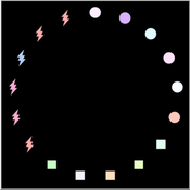
This project attempts to model how social media platforms recommend a user followers based on their interests, and how those individual interests change as a result of the influences from those they follow/are followed by.
We have three types of users on the platform:
Consumers (🔴), who update their interests based on who they’re following.
Creators (⬛), who update their interests based on who’s following them.
…
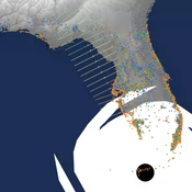
Peer reviewed CHIME ABM of Hurricane Evacuation
C Michael Barton Sean Bergin Joshua Watts Joshua Alland Rebecca Morss | Published Monday, October 18, 2021 | Last modified Tuesday, January 04, 2022The Communicating Hazard Information in the Modern Environment (CHIME) agent-based model (ABM) is a Netlogo program that facilitates the analysis of information flow and protective decisions across space and time during hazardous weather events. CHIME ABM provides a platform for testing hypotheses about collective human responses to weather forecasts and information flow, using empirical data from historical hurricanes. The model uses real world geographical and hurricane data to set the boundaries of the simulation, and it uses historical hurricane forecast information from the National Hurricane Center to initiate forecast information flow to citizen agents in the model.
A Simple Agent Based Modeling Tool for Plastic and Debris Tracking in Oceans
Subu Kandaswamy Koushik Sura Bhaskar Sai Amulya Murukutla Sai Pranay Raju Chinthala Abhishek Bobbillapati | Published Monday, October 04, 2021Plastics and the pollution caused by their waste have always been a menace to both nature and humans. With the continual increase in plastic waste, the contamination due to plastic has stretched to the oceans. Many plastics are being drained into the oceans and rose to accumulate in the oceans. These plastics have seemed to form large patches of debris that keep floating in the oceans over the years. Identification of the plastic debris in the ocean is challenging and it is essential to clean plastic debris from the ocean. We propose a simple tool built using the agent-based modeling framework NetLogo. The tool uses ocean currents data and plastic data both being loaded using GIS (Geographic Information System) to simulate and visualize the movement of floatable plastic and debris in the oceans. The tool can be used to identify the plastic debris that has been piled up in the oceans. The tool can also be used as a teaching aid in classrooms to bring awareness about the impact of plastic pollution. This tool could additionally assist people to realize how a small plastic chunk discarded can end up as large debris drifting in the oceans. The same tool might help us narrow down the search area while looking out for missing cargo and wreckage parts of ships or flights. Though the tool does not pinpoint the location, it might help in reducing the search area and might be a rudimentary alternative for more computationally expensive models.
Network Behaviour Diffusion
Jennifer Badham | Published Saturday, October 02, 2021This model implements two types of network diffusion from an initial group of activated nodes. In complex contagion, a node is activated if the proportion of neighbour nodes that are already activated exceeds a given threshold. This is intended to represented the spread of health behaviours. In simple contagion, an activated node has a given probability of activating its inactive neighbours and re-tests each time step until all of the neighbours are activated. This is intended to represent information spread.
A range of networks are included with the model from secondary school friendship networks. The proportion of nodes initially activated and the method of selecting those nodes are controlled by the user.
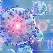
COVID-19 SIR with Public Health Interventions
Kit Martin Amber Cesare Matthew Johnson | Published Tuesday, September 28, 2021This is an extension of the basic Suceptible, Infected, Recovered (SIR) model. This model explores the spread of disease in two spaces, one a treatment, and one a control. Through the modeling options, one can explore how changing assumptions about the number of susceptible people, starting number of infected people, the disease’s infection probability, and average duration impacts the outcome. In addition, this version allows users to explore how public health interventions like social distancing, masking, and isolation can affect the number of people infected. The model shows that the interactions of agents, and the interventions can drastically affect the results of the model.
We used the model in our course about COVID-19: https://www.csats.psu.edu/science-of-covid19
Displaying 10 of 501 results from clear search