Our mission is to help computational modelers develop, document, and share their computational models in accordance with community standards and good open science and software engineering practices. Model authors can publish their model source code in the Computational Model Library with narrative documentation as well as metadata that supports open science and emerging norms that facilitate software citation, computational reproducibility / frictionless reuse, and interoperability. Model authors can also request private peer review of their computational models. Models that pass peer review receive a DOI once published.
All users of models published in the library must cite model authors when they use and benefit from their code.
Please check out our model publishing tutorial and feel free to contact us if you have any questions or concerns about publishing your model(s) in the Computational Model Library.
Displaying 10 of 1195 results for "Aad Kessler" clear search
Tram Commute
Julia Kasmire | Published Thursday, February 13, 2020 | Last modified Monday, March 02, 2020A demonstration model showing how modellers can create a multi regional tram network with commuters, destinations and houses. The model offers options to create a random tram network made from modeller input or to load shapefiles for the Greater Manchester Metrolink.
The model uses NetLogo with gis, nw an csv extensions.
The Effect of Different Governmental Pandemic Control Measures on the Spread of a Virus Disease
Chiara Letter | Published Wednesday, January 26, 2022In this model, the spread of a virus disease in a network consisting of school pupils, employed, and umemployed people is simulated. The special feature in this model is the distinction between different types of links: family-, friends-, school-, or work-links. In this way, different governmental measures can be implemented in order to decelerate or stop the transmission.
SugarscapeCW
Christopher Watts | Published Saturday, August 01, 2015 | Last modified Wednesday, April 12, 2023A replication in Netlogo 5.2 of the classic model, Sugarscape (Epstein & Axtell, 1996).
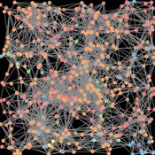
Agent-based model of team decision-making in hidden profile situations
Andreas Flache Jonas Stein Vincenz Frey | Published Thursday, April 20, 2023 | Last modified Friday, November 17, 2023The model presented here is extensively described in the paper ‘Talk less to strangers: How homophily can improve collective decision-making in diverse teams’ (forthcoming at JASSS). A full replication package reproducing all results presented in the paper is accessible at https://osf.io/76hfm/.
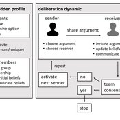
Narrative documentation includes a detailed description of the model, including a schematic figure and an extensive representation of the model in pseudocode.
The model develops a formal representation of a diverse work team facing a decision problem as implemented in the experimental setup of the hidden-profile paradigm. We implement a setup where a group seeks to identify the best out of a set of possible decision options. Individuals are equipped with different pieces of information that need to be combined to identify the best option. To this end, we assume a team of N agents. Each agent belongs to one of M groups where each group consists of agents who share a common identity.
The virtual teams in our model face a decision problem, in that the best option out of a set of J discrete options needs to be identified. Every team member forms her own belief about which decision option is best but is open to influence by other team members. Influence is implemented as a sequence of communication events. Agents choose an interaction partner according to homophily h and take turns in sharing an argument with an interaction partner. Every time an argument is emitted, the recipient updates her beliefs and tells her team what option she currently believes to be best. This influence process continues until all agents prefer the same option. This option is the team’s decision.
Peer reviewed Historical Letters
Bernardo Buarque Malte Vogl Jascha Merijn Schmitz Aleksandra Kaye | Published Thursday, May 16, 2024 | Last modified Friday, May 24, 2024A letter sending model with historically informed initial positions to reconstruct communication and archiving processes in the Republic of Letters, the 15th to 17th century form of scholarship.
The model is aimed at historians, willing to formalize historical assumptions about the letter sending process itself and allows in principle to set heterogeneous social roles, e.g. to evaluate the role of gender or social status in the formation of letter exchange networks. The model furthermore includes a pruning process to simulate the loss of letters to critically asses the role of biases e.g. in relation to gender, geographical regions, or power structures, in the creation of empirical letter archives.
Each agent has an initial random topic vector, expressed as a RGB value. The initial positions of the agents are based on a weighted random draw based on data from [2]. In each step, agents generate two neighbourhoods for sending letters and potential targets to move towards. The probability to send letters is a self-reinforcing process. After each sending the internal topic of the receiver is updated as a movement in abstract space by a random amount towards the letters topic.
…
Environmental knowledge inhibits hominin dispersal
Colin Wren | Published Thursday, November 09, 2017Local scale mobility, namely foraging, leads to global population dispersal. Agents acquire information about their environment in two ways, one individual and one social. See also http://www.openabm.org/model/3846/
Consumats on a network
Marco Janssen | Published Tuesday, January 14, 2020 | Last modified Tuesday, May 30, 2023Consumer agents make choices which products to choose using the consumat approach. In this approach agents will make choices using deliberation, repetition, imitation or social comparison dependent on the level of need satisfaction and uncertainty.
The model is discussed in Introduction to Agent-Based Modeling by Marco Janssen. For more information see https://intro2abm.com/
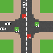
Modelling an intersection with traffic signal countdown timer
Eduard | Published Thursday, May 19, 2022Developed as a part of a project in the University of Augsburg, Institute of Geography, it simulates the traffic in an intersection or junction which uses either regular traffic lights or traffic lights with a countdown timer. The model tracks the average speed of cars before and after traffic lights as well as the throughput.
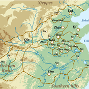
Evolutionary Dynamics of the Warring States Period: Initial Unification in Ancient China (475 BC to 221 BC)
zhuo zhang | Published Sunday, August 07, 2022If you have any questions about the model run, please send me an email and I will respond as soon as possible.
Under complex system perspectives, we build the multi-agent system to back-calculate this unification process of the Warring State period, from 32 states in 475 BC to 1 state (Qin) in 221 BC.
Virus Spread on Broad-degree-distribution Network.
Gianluca Manzo | Published Friday, July 24, 2020The model simulates the spread of a virus through a synthetic network with a degree distribution calibrated on close-range contact data. The model is used to study the macroscopic consequences of cross-individual variability in close-range contact frequencies and to assess whether this variability can be exploited for effective intervention targeting high-contact nodes.
Displaying 10 of 1195 results for "Aad Kessler" clear search