About the CoMSES Model Library more info
Our mission is to help computational modelers at all levels engage in the establishment and adoption of community standards and good practices for developing and sharing computational models. Model authors can freely publish their model source code in the Computational Model Library alongside narrative documentation, open science metadata, and other emerging open science norms that facilitate software citation, reproducibility, interoperability, and reuse. Model authors can also request peer review of their computational models to receive a DOI.
All users of models published in the library must cite model authors when they use and benefit from their code.
Please check out our model publishing tutorial and contact us if you have any questions or concerns about publishing your model(s) in the Computational Model Library.
We also maintain a curated database of over 7500 publications of agent-based and individual based models with additional detailed metadata on availability of code and bibliometric information on the landscape of ABM/IBM publications that we welcome you to explore.
Displaying 10 of 59 results urban clear
RecovUS: An Agent-Based Model of Post-Disaster Household Recovery
Saeed Moradi | Published Thursday, July 30, 2020The purpose of this model is to explain the post-disaster recovery of households residing in their own single-family homes and to predict households’ recovery decisions from drivers of recovery. Herein, a household’s recovery decision is repair/reconstruction of its damaged house to the pre-disaster condition, waiting without repair/reconstruction, or selling the house (and relocating). Recovery drivers include financial conditions and functionality of the community that is most important to a household. Financial conditions are evaluated by two categories of variables: costs and resources. Costs include repair/reconstruction costs and rent of another property when the primary house is uninhabitable. Resources comprise the money required to cover the costs of repair/reconstruction and to pay the rent (if required). The repair/reconstruction resources include settlement from the National Flood Insurance (NFI), Housing Assistance provided by the Federal Emergency Management Agency (FEMA-HA), disaster loan offered by the Small Business Administration (SBA loan), a share of household liquid assets, and Community Development Block Grant Disaster Recovery (CDBG-DR) fund provided by the Department of Housing and Urban Development (HUD). Further, household income determines the amount of rent that it can afford. Community conditions are assessed for each household based on the restoration of specific anchors. ASNA indexes (Nejat, Moradi, & Ghosh 2019) are used to identify the category of community anchors that is important to a recovery decision of each household. Accordingly, households are indexed into three classes for each of which recovery of infrastructure, neighbors, or community assets matters most. Further, among similar anchors, those anchors are important to a household that are located in its perceived neighborhood area (Moradi, Nejat, Hu, & Ghosh 2020).
Urban/Rural Adaptive Culture Model
Nick LaBerge | Published Sunday, July 19, 2020Contains python3 code used to replicate the culture model from the JASSS submission: “Modeling Cultural Dissemination and Divergence between Rural and Urban Regions.”
Hybrid individual- and particle-based simulation model and data on air pollutants and vertical greenery systems in the city of Yerevan, Armenia
Andranik Akopov | Published Friday, June 19, 2020Urban greenery such as vertical greenery systems (VGS) can effectively absorb air pollutants emitted by different agents, such as vehicles and manufacturing enterprises. The main challenge is how to protect socially important objects, such as kindergartens, from the influence if air pollution with the minimum of expenditure. There is proposed the hybrid individual- and particle-based model of interactions between vertical greenery systems and air pollutants to identify optimal locations of tree clusters and high-rise buildings where horizontal greenery systems and VGS should be implemented, respectively. The model is implemented in the AnyLogic simulation tool.
Informal City version 1.0
Nina Schwarz | Published Friday, July 25, 2014 | Last modified Thursday, July 30, 2015InformalCity, a spatially explicit agent-based model, simulates an artificial city and allows for testing configurations of urban upgrading schemes in informal settlements.
Exploring Urban Shrinkage
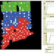
Andrew Crooks | Published Thursday, March 19, 2020While the world’s total urban population continues to grow, this growth is not equal. Some cities are declining, resulting in urban shrinkage which is now a global phenomenon. Many problems emerge due to urban shrinkage including population loss, economic depression, vacant properties and the contraction of housing markets. To explore this issue, this paper presents an agent-based model stylized on spatially explicit data of Detroit Tri-county area, an area witnessing urban shrinkage. Specifically, the model examines how micro-level housing trades impact urban shrinkage by capturing interactions between sellers and buyers within different sub-housing markets. The stylized model results highlight not only how we can simulate housing transactions but the aggregate market conditions relating to urban shrinkage (i.e., the contraction of housing markets). To this end, the paper demonstrates the potential of simulation to explore urban shrinkage and potentially offers a means to test polices to alleviate this issue.
Socio-hydrologicalModel_version_SESMO
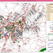
Andres Baeza-Castro Luis Bojorquez Marco Janssen Hallie Eakin Fidel Serrano-Candela Paola Gomez Yosune Miquelajauregui Rodrigo Garcia-Herrera | Published Tuesday, February 05, 2019We present here MEGADAPT_SESMO model. A hybrid, dynamic, spatially explicit, integrated model to simulate the vulnerability of urban coupled socio-ecological systems – in our case, the vulnerability of Mexico City to socio-hydrological risk.
MEGADAPT - Socio-hydrological risk model - Theoretical (no data) implementation
Andres Baeza-Castro Luis Bojorquez Marco Janssen Hallie Eakin | Published Wednesday, February 06, 2019The model simulates the decisions of residents and a water authority to respond to socio-hydrological hazards. Residents from neighborhoods are located in a landscape with topographic complexity and two problems: water scarcity in the peripheral neighborhoods at high altitude and high risk of flooding in the lowlands, at the core of the city. The role of the water authority is to decide where investments in infrastructure should be allocated to reduce the risk to water scarcity and flooding events in the city, and these decisions are made via a multi-objective site selection procedure. This procedure accounts for the interdependencies and feedback between the urban landscape and a policy scenario that defines the importance, or priorities, that the authority places on four criteria.
Neighborhoods respond to the water authority decisions by protesting against the lack of investment and the level of exposure to water scarcity and flooding. Protests thus simulate a form of feedback between local-level outcomes (flooding and water scarcity) and higher-level decision-making. Neighborhoods at high altitude are more likely to be exposed to water scarcity and lack infrastructure, whereas neighborhoods in the lowlands tend to suffer from recurrent flooding. The frequency of flooding is also a function of spatially uniform rainfall events. Likewise, neighborhoods at the periphery of the urban landscape lack infrastructure and suffer from chronic risk of water scarcity.
The model simulates the coupling between the decision-making processes of institutional actors, socio-political processes and infrastructure-related hazards. In the documentation, we describe details of the implementation in NetLogo, the description of the procedures, scheduling, and the initial conditions of the landscape and the neighborhoods.
This work was supported by the National Science Foundation under Grant No. 1414052, CNH: The Dynamics of Multi-Scalar Adaptation in Megacities (PI Hallie Eakin).
City Sandbox
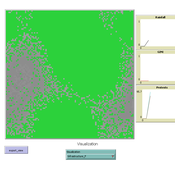
Javier Sandoval | Published Thursday, January 09, 2020This model grows land use patterns that emerge as a result of land-use compatibilities stablished in urban development plans, land topography, and street networks. It contains urban brushes to paint streets and land uses as a way to learn about urban pattern emergence through free experimentation.
Cultural Evolution of Sustainable Behaviours: Landscape of Affordances Model
Roope Oskari Kaaronen Nikita Strelkovskii | Published Wednesday, December 04, 2019 | Last modified Wednesday, December 04, 2019This NetLogo model illustrates the cultural evolution of pro-environmental behaviour patterns. It illustrates how collective behaviour patterns evolve from interactions between agents and agents (in a social network) as well as agents and the affordances (action opportunities provided by the environment) within a niche. More specifically, the cultural evolution of behaviour patterns is understood in this model as a product of:
- The landscape of affordances provided by the material environment,
- Individual learning and habituation,
- Social learning and network structure,
- Personal states (such as habits and attitudes), and
…
Urban Dynamics
Hideyuki Nagai | Published Monday, November 11, 2019This is an urban dynamics ABM of abstraction of a city and residents’ activities there.
It allows you to evaluate the effects of urban policies, such as an introduction of an open facility for residents with pedestrian-friendly accommodations, promotion of bicycle use, and control of private automobile use in an urban central area, in controlling urban sprawl.
Displaying 10 of 59 results urban clear