About the CoMSES Model Library more info
Our mission is to help computational modelers at all levels engage in the establishment and adoption of community standards and good practices for developing and sharing computational models. Model authors can freely publish their model source code in the Computational Model Library alongside narrative documentation, open science metadata, and other emerging open science norms that facilitate software citation, reproducibility, interoperability, and reuse. Model authors can also request peer review of their computational models to receive a DOI.
All users of models published in the library must cite model authors when they use and benefit from their code.
Please check out our model publishing tutorial and contact us if you have any questions or concerns about publishing your model(s) in the Computational Model Library.
We also maintain a curated database of over 7500 publications of agent-based and individual based models with additional detailed metadata on availability of code and bibliometric information on the landscape of ABM/IBM publications that we welcome you to explore.
Displaying 10 of 90 results landscape clear search
Change and Senescence
André Martins | Published Tuesday, November 10, 2020Agers and non-agers agent compete over a spatial landscape. When two agents occupy the same grid, who will survive is decided by a random draw where chances of survival are proportional to fitness. Agents have offspring each time step who are born at a distance b from the parent agent and the offpring inherits their genetic fitness plus a random term. Genetic fitness decreases with time, representing environmental change but effective non-inheritable fitness can increase as animals learn and get bigger.
PaCE Austria Pilot Model
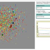
Ruth Meyer | Published Tuesday, June 30, 2020The objective of building a social simulation in the Populism and Civic Engagement (PaCE) project is to study the phenomenon of populism by mapping individual level political behaviour and explain the influence of agents on, and their interdependence with the respective political parties. Voters, political parties and – to some extent – the media can be viewed as forming a complex adaptive system, in which parties compete for citizens’ votes, voters decide on which party to vote for based on their respective positions with regard to particular issues, and the media may influence the salience of issues in the public debate.
This is the first version of a model exploring voting behaviour in Austria. It focusses on modelling the interaction of voters and parties in a political landscape; the effects of the media are not yet represented. Austria was chosen as a case study because it has an established populist party (the “Freedom Party” FPO), which has even been part of the government over the years.
A simple model that aims to demonstrate the influence of agri-environmental payments on land-use patterns in a virtual landscape. The landscape consists of grassland (which can be managed extensively or intensively) and a river. Agri-environmental payments are provided for extensive management of grassland. Additionally, there are boni for (a) extensive grassland in proximity of the river; and (b) clusters (“agglomerations”) of extensive grassland. The farmers, who own randomly distributed grassland patches, make decisions either on the basis of simple income maximization or they maximize only up to an income threshold beyond which they seize making changes in management. The resulting landscape pattern is evaluated by means of three simple models for (a) agricultural yield, (b) habitat/biodiversity and (c) water quality. The latter two correspond to the two boni. The model has been developed within a small project called Aligning Agent-Based Modelling with Multi-Objective Land-Use Allocation (ALABAMA).
Rangeland and evolution of management styles
Marco Janssen | Published Tuesday, January 14, 2020Provided is a landscape of properties where pastoralists make decisions how much livestock they put on their property and how much to suppress fire from occuring. Rangelands can be grass dominated, or unproductive shrubb dominated. Overgrazing and fire suppresion lead to shrub dominated landscapes. What management strategies evolve, and how is this impacted by policies?
The model is discussed in Introduction to Agent-Based Modeling by Marco Janssen. For more information see https://intro2abm.com/.
Sugarscape with spice
Marco Janssen | Published Tuesday, January 14, 2020 | Last modified Friday, September 18, 2020This is a variation of the Sugarspace model of Axtell and Epstein (1996) with spice and trade of sugar and spice. The model is not an exact replication since we have a somewhat simpler landscape of sugar and spice resources included, as well as a simple reproduction rule where agents with a certain accumulated wealth derive an offspring (if a nearby empty patch is available).
The model is discussed in Introduction to Agent-Based Modeling by Marco Janssen. For more information see https://intro2abm.com/
Managing networked landscapes: conservation in fragmented, regionally connected world
Jacopo A. Baggio Michael Schoon Sechindra Vallury | Published Monday, December 09, 2019Exploring how learning and social-ecological networks influence management choice set and their ability to increase the likelihood of species coexistence (i.e. biodiversity) on a fragmented landscape controlled by different managers.
Cultural Evolution of Sustainable Behaviours: Landscape of Affordances Model
Nikita Strelkovskii Roope Oskari Kaaronen | Published Wednesday, December 04, 2019 | Last modified Wednesday, December 04, 2019This NetLogo model illustrates the cultural evolution of pro-environmental behaviour patterns. It illustrates how collective behaviour patterns evolve from interactions between agents and agents (in a social network) as well as agents and the affordances (action opportunities provided by the environment) within a niche. More specifically, the cultural evolution of behaviour patterns is understood in this model as a product of:
- The landscape of affordances provided by the material environment,
- Individual learning and habituation,
- Social learning and network structure,
- Personal states (such as habits and attitudes), and
…
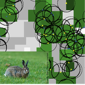
Mitigating bioenergy-driven biodiversity decline: a modelling approach with the European brown hare
Volker Grimm Maria Langhammer | Published Wednesday, November 13, 2019 | Last modified Tuesday, November 24, 2020The model is designed to analyse the effects of mitigation measures on the European brown hare (Lepus europaeus), which is directly affected by ongoing land use change and has experienced widespread decline throughout Europe since the 1960s. As an input, we use two 4×4 km large model landscapes, which were generated by a landscape generator based on real field sizes and crop proportions and differed in average field size and crop composition. The crops grown annually are evaluated in terms of forage suitability, breeding suitability and crop richness for the hare. Six mitigation scenarios are implemented, defined by a 10 % increase in: (1) mixed silphie, (2) miscanthus, (3) grass-clover ley, (4) alfalfa, (5) set-aside, and (6) general crop richness. The model shows that that both landscape configuration and composition have a significant effect on hare population development, which responds particularly strongly to compositional changes.
Policies to reconnect a city and the countryside
Gert Jan Hofstede Tim Verwaart | Published Monday, September 23, 2019The agent-based model captures the spatio-temporal institutional dynamics of the economy over the years at the level of a Dutch province. After 1945, Noord-Brabant in the Netherlands has been subject to an active program of economic development through the stimulation of pig husbandry. This has had far-reaching effects on its economy, landscape, and environment. The agents are households. The simulation is at institutional level, with typical stakeholder groups, lobbies, and political parties playing a role in determining policies that in turn determine economic, spatial and ecological outcomes. It allows to experiment with alternative scenarios based on two political dimensions: local versus global issues, and economic versus social responsibilitypriorities. The model shows very strong sensitivity to political context. It can serve as a reference model for other cases where “artificial institutional economics” is attempted.
TIP TOP Landscape
Patrick Taillandier Nesrine Ayari Claude Janin Benoit Sarrazin Dominique Trévisan | Published Wednesday, September 04, 2019The model aims at reproducing the evolution of the land-use in an agricultural territory at the plot scale. It enables to simulate the affectation of land-use, the crop rotation and technical operations for each plot of the different farms of the territory. It allows as well for crop farms to simulate the daily state of plots (sowed, plowed, harvested, biomass indicator). The model is used as an input for the water pollution model allowing to determine the flow of nitrate, phosphorus and suspended matter in the territory according to the landscape configuration.
Displaying 10 of 90 results landscape clear search