Our mission is to help computational modelers develop, document, and share their computational models in accordance with community standards and good open science and software engineering practices. Model authors can publish their model source code in the Computational Model Library with narrative documentation as well as metadata that supports open science and emerging norms that facilitate software citation, computational reproducibility / frictionless reuse, and interoperability. Model authors can also request private peer review of their computational models. Models that pass peer review receive a DOI once published.
All users of models published in the library must cite model authors when they use and benefit from their code.
Please check out our model publishing tutorial and feel free to contact us if you have any questions or concerns about publishing your model(s) in the Computational Model Library.
Displaying 10 of 1019 results for "Rolf Anker Ims" clear search
Model of a Socioterritorial complex system - The Southern Rural Territory of Sergipe
Marcos Aurélio Santos da Silva | Published Friday, May 18, 2018The model represents a set of social actors engaged into a collegiate (composed of representants of civil society and public sector) to manage the Southern Rural Territory of Sergipe (SRTS), created by two territorial public policies, the National Program for the Sustainable Development of Rural Territories (PRONAT) and the Program Territories of Citizenship (PTC) which aim at balancing power relations between social actors of Rural Territories. The main gola of these public policies is to empower the civil society engaged in the territory to enable them to negotiate with the traditional power (mainly majors). It was designed two models of the SRTS, one that represents the situation in 2012, and other that represents the social interdependencies in 2017. For each period it is possible to measure the capability and power of each modeled social actor and see whether it is observed the empowerment of the civil society or not.
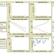
Population size limits the coefficient of variation in continuous traits affected by proportional copying error
Luke Premo | Published Thursday, June 18, 2020This version of the accumulated copying error (ACE) model is designed to address the following research question: how does finite population size (N) affect the coefficient of variation (CV) of a continuous cultural trait under the assumptions that the only source of copying error is visual perception error and that the continuous trait can take any positive value (i.e., it has no upper bound)? The model allows one to address this question while assuming the continuous trait is transmitted via vertical transmission, unbiased transmission, prestige biased transmission, mean conformist transmission, or median conformist transmission. By varying the parameter, p, one can also investigate the effect of population size under a mix of vertical and non-vertical transmission, whereby on average (1-p)N individuals learn via vertical transmission and pN individuals learn via either unbiased transmission, prestige biased transmission, mean conformist transmission, or median conformist transmission.
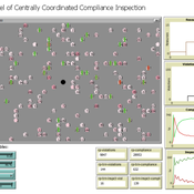
ICARUS - a multi-agent compliance inspection model
Slaven Smojver | Published Monday, May 09, 2022ICARUS is a multi-agent compliance inspection model (ICARUS - Inspecting Compliance to mAny RUleS). The model is applicable to environments where an inspection agency, via centrally coordinated inspections, examines compliance in organizations which must comply with multiple provisions (rules). The model (ICARUS) contains 3 types of agents: entities, inspection agency and inspectors / inspections. ICARUS describes a repeated, simultaneous, non-cooperative game of pure competition. Agents have imperfect, incomplete, asymmetric information. Entities in each move (tick) choose a pure strategy (comply/violate) for each rule, depending on their own subjective assessment of the probability of the inspection. The Inspection Agency carries out the given inspection strategy.
A more detailed description of the model is available in the .nlogo file.
Full description of the model (in line with the ODD+D protocol) and the analysis of the model (including verification, validation and sensitivity analysis) can be found in the attached documentation.
Parental Investment Model (Aktipis and Fernandez-Duque)
Athena Aktipis | Published Saturday, July 17, 2010 | Last modified Saturday, April 27, 2013This is version 1 of the Parental Investment Model by Aktipis & Fernandez-Duque.
Irrigation game
Marco Janssen | Published Monday, July 23, 2012 | Last modified Saturday, April 27, 2013Irrigation game calibrated on experimental data
Model of Context Switching with Segregation
Davide Nunes | Published Thursday, August 02, 2012 | Last modified Saturday, April 27, 2013In the context switching model, a society of agents embedded in multiple social relations, engages in a simple abstract game: the consensus game. Each agent has to choose towards one of two possible choices which are basically arbitrary. The objective of the game is to reach a global consensus, but the particular choice that gets collectively selected is irrelevant.
Peer reviewed Pumpa irrigation model
Marco Janssen Irene Perez Ibarra | Published Wednesday, January 09, 2013 | Last modified Saturday, April 27, 2013This is a replication of the Pumpa model that simulates the Pumpa Irrigation System in Nepal (Cifdaloz et al., 2010).
Peer reviewed Gender desegregation in German high schools
Klaus G. Troitzsch | Published Tuesday, February 05, 2019 | Last modified Sunday, November 08, 2020The study goes back to a model created in the 1990s which successfully tried to replicate the changes of the percentages of female teachers among the teaching staff in high schools (“Gymnasien”) in the German federal state of Rheinland-Pfalz. The current version allows for additional validation and calibration of the model and is accompanied with the empirical data against which the model is tested and with an analysis program especially designed to perform the analyses in the most recent journal article.
An agent-based artificial stock with a dynamic investor network
Matthew Oldham | Published Tuesday, June 25, 2019The model is an agent-based artificial stock market where investors connect in a dynamic network. The network is dynamic in the sense that the investors, at specified intervals, decide whether to keep their current adviser (those investors they receive trading advise from). The investors also gain information from a private source and share public information about the risky asset. Investors have different tendencies to follow the different information sources, consider differing amounts of history, and have different thresholds for investing.
PowerGen-ABM
Muhammad Indra Al Irsyad Anthony Halog Rabindra Nepal Deddy Priatmodjo Koesrindartoto | Published Sunday, August 04, 2019PowerGen-ABM is an optimisation model for power plant expansions from 2010 to 2025 with Indonesian electricity systems as the case study. PowerGen-ABM integrates three approaches: techno-economic analysis (TEA), linear programming (LP), and input-output analysis (IOA) and environmental analysis. TEA is based on the revenue requirement (RR) formula by UCDavis (2016), and the environmental analysis accounts for resource consumption (i.e., steel, concrete, aluminium, and energy) and carbon dioxide equivalent (CO2e) emissions during the construction and operational stages of power plants.
Displaying 10 of 1019 results for "Rolf Anker Ims" clear search