Our mission is to help computational modelers develop, document, and share their computational models in accordance with community standards and good open science and software engineering practices. Model authors can publish their model source code in the Computational Model Library with narrative documentation as well as metadata that supports open science and emerging norms that facilitate software citation, computational reproducibility / frictionless reuse, and interoperability. Model authors can also request private peer review of their computational models. Models that pass peer review receive a DOI once published.
All users of models published in the library must cite model authors when they use and benefit from their code.
Please check out our model publishing tutorial and feel free to contact us if you have any questions or concerns about publishing your model(s) in the Computational Model Library.
Displaying 10 of 142 results spatial clear search
ABMIND: An Empirically Informed Agent-Based Model of Psychological Distance and Environmental Protection Behavior
Wenhan Feng | Published Saturday, June 13, 2026ABMIND, the Agent-Based Model of Individual Psychological Distance, is a modeling framework developed to examine how psychological distance influences environmental protection behavior in coastal farming communities in southern China. Using household survey data and empirically estimated behavioral pathways, the model represents how uncertainty shapes four dimensions of psychological distance, namely temporal, spatial, social and hypothetical distance, and how these dimensions guide protection and degradation decisions. Agents include households, government actors and mangrove ecosystem patches, connected through social networks and ecological feedbacks that affect learning, expectations and perceived benefits. Policy interventions such as rewards, penalties and publicity guidance efforts work by modifying uncertainty and psychological distance rather than directly controlling behavior. ABMIND is implemented as a spatially explicit model following the ODD protocol, and a concise user guide is provided. In developing ABMIND we introduce a structured validation workflow that links statistical mediation analysis with simulation-based diagnostics, allowing empirical cognitive mechanisms to be systematically embedded and tested within the ABM. This integrated approach strengthens the credibility of psychological-mechanism models and supports their use in policy evaluation. The framework offers a methodological platform for integrating cognitive mechanisms into agent-based environmental behavior modeling and for evaluating policy strategies that support ecosystem protection.
Model paper:
ABMIND: An empirically informed agent-based model of psychological distance and environmental protection behaviour
Ecological Modelling
https://doi.org/10.1016/j.ecolmodel.2026.111700
Modeling Civilian Loyalty and Territorial Control in Irregular Warfare: An Agent-Based Model
Andrea Molle | Published Thursday, April 09, 2026An agent-based model of irregular warfare in which civilians adapt their alignment in response to local violence, security presence, and territorial control. The simulation explores how decentralized interactions generate spatial patterns of loyalty, conflict dynamics, and stabilization.
NetLogo Model of Spatial Eviction in Attraction-Repulsion Opinion Dynamics
poyeker | Published Friday, March 13, 2026A reproducible NetLogo implementation of a spatial attraction-repulsion opinion model with eviction-driven relocation. Agents interact locally, converge with similar neighbors, diverge from dissimilar neighbors, and may evict the most dissimilar neighbor to a random empty location. Parameter sweeps reveal transitions among extremist, mixed, and consensus regimes, with outputs including phase diagrams, opinion distributions, and Moran’s I. The model is intended to reproduce and extend results on how exclusion frequency changes polarization outcomes.
Selective Depolarization by Endogenous Migration in Attraction-Repulsion Opinion Dynamics (NetLogo)
poyeker | Published Tuesday, February 17, 2026This model implements a coupled opinion-mobility agent-based framework in NetLogo, extending Attraction-Repulsion Model (ARM) dynamics with endogenous migration in continuous 2D space.
Each agent has an opinion s in [0,1] and a spatial position (x,y). Agents interact locally within an interaction radius, with exposure-controlled interaction probability. Opinion updates follow ARM rules: attraction for small opinion distance and repulsion for large distance (tolerance threshold T). After social interaction, agents move according to a social-force mechanism that balances attraction to similar neighbors and avoidance of dissimilar neighbors, controlled by orientation bias (approaching goods vs leaving bads). The model also includes an optional exposure-mobility coupling setting.
Main outputs include polarization (P), spatial assortativity (Moran’s I), mixed-neighbor fraction (f_mix), and good-component count (N_g). The model is designed to study phase behavior of polarization and segregation under mobility and tolerance heterogeneity.
…
Replica of Turchin's (2003) Metaethnic Frontier model
Paul Smaldino | Published Sunday, February 15, 2026In his 2003 book, Historical Dynamics (ch. 4), Turchin describes and briefly analyzes a spatial ABM of his metaethnic frontier theory, which is essentially a formalization of a theory by Ibn Khaldun in the 14th century. In the model, polities compete with neighboring polities and can absorb them into an empire. Groups possess “asabiya”, a measure of social solidarity and a sense of shared purpose. Regions that share borders with other groups will have increased asabiya do to salient us vs. them competition. High asabiya enhances the ability to grow, work together, and hence wage war on neighboring groups and assimilate them into an empire. The larger the frontier, the higher the empire’s asabiya.
As an empire expands, (1) increased access to resources drives further growth; (2) internal conflict decreases asabiya among those who live far from the frontier; and (3) expanded size of the frontier decreases ability to wage war along all frontiers. When an empire’s asabiya decreases too much, it collapses. Another group with more compelling asabiya eventually helps establish a new empire.
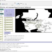
Geospatial Agent-Based Model of Immigrant Settlement Dynamics in Metro Vancouver
Liliana Perez Navid Mahdizadeh Gharakhanlou Maryam Yousefi | Published Wednesday, December 03, 2025This agent-based model simulates how new immigrant households choose where to live in Metro Vancouver under the origins diversity scenario. The model begins with 16,000 household agents, reflecting an expected annual population increase of about 42,500 people based on an average household size of 2.56. Each agent is assigned four characteristics: one of ten origin categories, income level (adjusted using NOC data and recent immigrant earnings), likelihood of having children, and preferred mode of commuting. The ten origin groups are drawn from Census patterns, including six subgroups within the broader Asian category (China, India, the Philippines, Iran, South Korea, and Other Asian countries) and two categories for immigrants from the Americas. This refined classification better captures the diversity of newcomers arriving in the region.
Logônia: Plant Growth Response Model in NetLogo
Leandro Garcia Daniel Vartanian Aline | Published Saturday, September 13, 2025 | Last modified Tuesday, September 16, 2025Logônia is a NetLogo model that simulates the growth response of a fictional plant, logônia, under different climatic conditions. The model uses climate data from WorldClim 2.1 and demonstrates how to integrate the LogoClim model through the LevelSpace extension.
Logônia follows the FAIR Principles for Research Software (Barker et al., 2022) and is openly available on the CoMSES Network and GitHub.
Urban Teacher Lifecycle and Mobility
Yevgeny Patarakin | Published Wednesday, July 23, 2025This agent-based model simulates the lifecycle, movement, and satisfaction of teachers within an urban educational system composed of multiple universities and schools. Each teacher agent transitions through several possible roles: newcomer, university student, unemployed graduate, and employed teacher. Teachers’ pathways are shaped by spatial configuration, institutional capacities, individual characteristics, and dynamic interactions with schools and universities. Universities are assigned spatial locations with a controllable level of centralization and are characterized by academic ratings, capacity, and alumni records. Schools are distributed throughout the city, each with a limited number of vacancies, hiring requirements, and offered salaries. Teachers apply to universities based on the alignment of their personal academic profiles with institutional ratings, pursue studies, and upon graduation become candidates for employment at schools.
The employment process is driven by a decentralized matching of teacher expectations and school offers, taking into account factors such as salary, proximity, and peer similarity. Teachers’ satisfaction evolves over time, reflecting both institutional characteristics and the composition of their colleagues; low satisfaction may prompt teachers to transfer between schools within their mobility radius. Mortality and teacher attrition further shape workforce dynamics, leading to continuous recruitment of newcomers to maintain a stable population. The model tracks university reputation through the academic performance and number of alumni, and visualizes key metrics including teacher status distribution, school staffing, university alumni counts, and overall satisfaction. This structure enables the exploration of policy interventions, hiring and training strategies, and the impact of spatial and institutional design on the allocation, retention, and happiness of urban educational staff.
LogoClim: WorldClim in NetLogo
Daniel Vartanian Leandro Garcia Aline Martins de Carvalho Aline | Published Thursday, July 03, 2025 | Last modified Tuesday, September 16, 2025LogoClim is a NetLogo model for simulating and visualizing global climate conditions. It allows researchers to integrate high-resolution climate data into agent-based models, supporting reproducible research in ecology, agriculture, environmental sciences, and other fields that rely on climate data.
The model utilizes raster data to represent climate variables such as temperature and precipitation over time. It incorporates historical data (1951-2024) and future climate projections (2021-2100) derived from global climate models under various Shared Socioeconomic Pathways (SSPs, O’Neill et al., 2017). All climate inputs come from WorldClim 2.1, a widely used source of high-resolution, interpolated climate datasets based on weather station observations worldwide (Fick & Hijmans, 2017).
LogoClim follows the FAIR Principles for Research Software (Barker et al., 2022) and is openly available on the CoMSES Network and GitHub. See the Logônia model for an example of its integration into a full NetLogo simulation.

BESTMAP-ABM-DE is an agent-based model to determine the adoption and spatial allocation of selected agri-environmental schemes (AES) by individual farmers in the Mulde River Basin located in Western Saxony, Germany. The selected AES are buffer areas, cover crops, maintaining permanent grassland and conversion of arable land to permanent grassland. While the first three schemes have already been offered in the case study area, the latter scheme is a hypothetical scheme designed to test the impact of potential policy changes. For the first model analyses, only the currently offered schemes are considered. With the model, the effect of different scenarios of policy design on patterns of adoption can be investigated. In particular, the model can be used to study the social-ecological consequences of agricultural policies at different spatial and temporal scales and, in combination with biophysical models, test the ecological implications of different designs of the EU’s Common Agricultural Policy. The model was developed in the BESTMAP project.
Displaying 10 of 142 results spatial clear search