
Gary Polhill
Affiliations Professional homepagehttp://www.hutton.ac.uk/staff/gary-polhill
ORCID more infoNo associated ORCID account.
GitHub more infoNo associated GitHub account.
Gary Polhill did a degree in Artificial Intelligence and a PhD in Neural Networks before spending 18 months in industry as a professional programmer. Since 1997 he has been working at the Institute on agent-based modelling of human-natural systems, and has worked on various international and interdisciplinary projects using agent-based modelling to study agricultural systems, lifestyles, and transitions to more sustainable ways of living. In 2016, he was elected President of the European Social Simulation Association, and was The James Hutton Institute’s 2017 Science Challenge Leader on Developing Technical and Social Innovations that Support Sustainable and Resilient Communities.
Protein 2.0: An Agent-Based Model for Simulating Norway’s Protein Sector Under Carbon Pricing and the Emergence of Cultivated Proteins
Gary Polhill Nick Roxburgh Rob J.F. Burton Klaus Mittenzwei | Published Thursday, May 08, 2025Protein 2.0 is a systems model of the Norwegian protein sector designed to explore the potential impacts of carbon taxation and the emergence of cultivated meat and dairy technologies. The model simulates production, pricing, and consumption dynamics across conventional and cultivated protein sources, accounting for emissions intensity, technological learning, economies of scale, and agent behaviour. It assesses how carbon pricing could alter the competitiveness of conventional beef, lamb, pork, chicken, milk, and egg production relative to emerging cultivated alternatives, and evaluates the implications for domestic production, emissions, and food system resilience. The model provides a flexible platform for exploring policy scenarios and transition pathways in protein supply. Further details can be found in the associated publication.
The code shared here accompanies the paper at https://doi.org/10.1371/journal.pone.0208451. It simulates the effects of various economic trade scenarios on the phenomenon of the ‘disappearing middle’ in the Scottish beef and dairy farming industries. The ‘disappearing middle’ is a situation in which there is a simultaneous observed decline in medium-sized enterprises and rise in the number of small and large-scale enterprises.
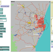
Transport simulation in a real road network
Gary Polhill Jiaqi Ge | Published Tuesday, April 17, 2018 | Last modified Tuesday, April 17, 2018Ge, J., & Polhill, G. (2016). Exploring the Combined Impact of Factors Influencing Commuting Patterns and CO2 Emission in Aberdeen Using an Agent-Based Model. Journal of Artificial Societies and Social Simulation, 19(3). http://jasss.soc.surrey.ac.uk/19/3/11.html
We develop an agent-based transport model using a realistic GIS-enabled road network and the car following method. The model can be used to study the impact of social interventions such as flexi-time and workplace sharing, as well as large infrastructure such as the construction of a bypass or highway. The model is developed in Netlogo version 5 and requires road network data in GIS format to run.
FEARLUS-SPOMM
Dawn Parker Gary Polhill Nick Gotts Alistair Law Luis Izquierdio Alessandro Gimona Lee-Ann Sutherland | Published Friday, March 25, 2016This is a coupled conceptual model of agricultural land decision-making and incentivisation and species metacommunities.
Under development.