Our mission is to help computational modelers develop, document, and share their computational models in accordance with community standards and good open science and software engineering practices. Model authors can publish their model source code in the Computational Model Library with narrative documentation as well as metadata that supports open science and emerging norms that facilitate software citation, computational reproducibility / frictionless reuse, and interoperability. Model authors can also request private peer review of their computational models. Models that pass peer review receive a DOI once published.
All users of models published in the library must cite model authors when they use and benefit from their code.
Please check out our model publishing tutorial and feel free to contact us if you have any questions or concerns about publishing your model(s) in the Computational Model Library.
Displaying 10 of 79 results risk clear search
A discrete-time stochastic model with state-dependent transmission probabilities and multi-agent simulations focusing on possible risks that could materialize in the final phase of the epidemic.
Peer reviewed JuSt-Social COVID-19
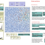
Jennifer Badham | Published Thursday, June 18, 2020 | Last modified Monday, March 29, 2021NetLogo model that allows scenarios concerning general social distancing, shielding of high-risk individuals, and informing contacts when symptomatic. Documentation includes a user manual with some simple scenarios, and technical information including descriptions of key procedures and parameter values.
Wildlife-Human Interactions in Shared Landscapes (WHISL)
Nicholas Magliocca Neil Carter Andres Baeza-Castro | Published Friday, May 22, 2020This model simulates a group of farmers that have encounters with individuals of a wildlife population. Each farmer owns a set of cells that represent their farm. Each farmer must decide what cells inside their farm will be used to produce an agricultural good that is self in an external market at a given price. The farmer must decide to protect the farm from potential encounters with individuals of the wildlife population. This decision in the model is called “fencing”. Each time that a cell is fenced, the chances of a wildlife individual to move to that cell is reduced. Each encounter reduces the productive outcome obtained of the affected cell. Farmers, therefore, can reduce the risk of encounters by exclusion. The decision of excluding wildlife is made considering the perception of risk of encounters. In the model, the perception of risk is subjective, as it depends on past encounters and on the perception of risk from other farmers in the community. The community of farmers passes information about this risk perception through a social network. The user (observer) of the model can control the importance of the social network on the individual perception of risk.
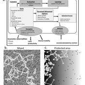
Hydroman is a flexible spatially explicit model coupling human and hydrological processes to explore shallow water tables and land cover interactions in flat agricultural landscapes, modeled after the Argentine Pampas. Hydroman aligned well with established hydrological models, and was validated with water table patterns and crop yield observed in the study area.
Agent-based model of repeated conservation auctions in low-income countries
Sebastian Rasch Elsa Cardona Hugo Storm | Published Sunday, March 22, 2020Our model allows simulating repeated conservation auctions in low-income countries. It is designed to assess policy-making by exploring the extent to which non-targeted repeated auctions can provide biodiversity conservation cost-effectively, while alleviating poverty. Targeting landholders in order to integrate both goals is claimed to be overambitious and underachieving because of the trade-offs they imply. The simulations offer insight on the possible outcomes that can derive from implementing conservation auctions in low-income countries, where landholders are likely to be risk averse and to face uncertainty.
Do microfinance institutes help slum-dwellers in coping with frequent disasters? An Agent-Based Modelling study
Mitali Yeshwant Yeshwant Joshi | Published Friday, March 13, 2020The model aims to investigate the role of Microfinance Institutes (MFIs) in strengthening the coping capacity of slum-dwellers (residents) in case of frequent disasters. The main purpose of the model is system understanding. It aids in understanding the following research question: Are the microcredits provided by MFI to start a small business helpful in increasing coping capacity of a slum dweller for recovering from frequent and intense disasters?
Peer reviewed Lethal Geometry
Kristin Crouse | Published Friday, February 21, 2020 | Last modified Wednesday, December 15, 2021LethalGeometry was developed to examine whether territory size influences the mortality risk for individuals within that territory. For animals who live in territoral groups and are lethally aggressive, we can expect that most aggression occurs along the periphery (or border) between two adjacent territories. For territories that are relatively large, the periphery makes up a proportionately small amount of the of the total territory size, suggesting that individuals in these territories might be less likely to die from these territorial skirmishes. LethalGeometry examines this geometric relationship between territory size and mortality risk under realistic assumptions of variable territory size and shape, variable border width, and stochastic interactions and movement.
The individuals (agents) are programmed to walk randomly about their environment, search for and eat food to obtain energy, reproduce if they can, and act aggressively toward individuals of other groups. During each simulation step, individuals analyze their environment and internal state to determine which actions to take. The actions available to individuals include moving, fighting, and giving birth.
Spatio-Temporal Dynamic of Risk Model
J Jumadi | Published Tuesday, October 22, 2019 | Last modified Sunday, January 05, 2020This model aims to simlulate the dynamic of risk over time and space.
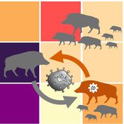
Classical Swine Fever in wild boars
Volker Grimm Stephanie Kramer-Schadt Cédric Scherer Martin Lange Hans-Hermann Thulke | Published Friday, September 06, 2019The model is a combination of a spatially explicit, stochastic, agent-based model for wild boars (Sus scrofa L.) and an epidemiological model for the Classical Swine Fever (CSF) virus infecting the wild boars.
The original model (Kramer-Schadt et al. 2009) was used to assess intrinsic (system immanent host-pathogen interaction and host life-history) and extrinsic (spatial extent and density) factors contributing to the long-term persistence of the disease and has further been used to assess the effects of intrinsic dynamics (Lange et al. 2012a) and indirect transmission (Lange et al. 2016) on the disease course. In an applied context, the model was used to test the efficiency of spatiotemporal vaccination regimes (Lange et al. 2012b) as well as the risk of disease spread in the country of Denmark (Alban et al. 2005).
References: See ODD model description.
Coupled Housing and Land Markets (CHALMS)
Nicholas Magliocca | Published Thursday, August 29, 2019An economic agent-based model of Coupled Housing and Land Markets (CHALMS) simulates the location choices, insurance purchasing decisions, and risk perceptions of coastal residents, and how coastal risks are capitalized (or not) into coastal housing and land markets.
Displaying 10 of 79 results risk clear search