Our mission is to help computational modelers develop, document, and share their computational models in accordance with community standards and good open science and software engineering practices. Model authors can publish their model source code in the Computational Model Library with narrative documentation as well as metadata that supports open science and emerging norms that facilitate software citation, computational reproducibility / frictionless reuse, and interoperability. Model authors can also request private peer review of their computational models. Models that pass peer review receive a DOI once published.
All users of models published in the library must cite model authors when they use and benefit from their code.
Please check out our model publishing tutorial and feel free to contact us if you have any questions or concerns about publishing your model(s) in the Computational Model Library.
Displaying 10 of 1229 results for "Lee-Ann Sutherland" clear search
University Connectivity
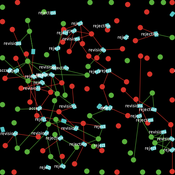
Rachel Wozniak Nick Glover Chris English Juan Cisneros | Published Tuesday, November 30, 2021This model is designed to show the effects of personality types and student organizations have on ones chance to making friendships in a university setting. As known from psychology studies, those that are extroverted have an easier chance making friendships in comparison to those that are introverted.
Once every tick a pair of students (nodes) will be randomly selected they will then have the chance to either be come friends or not (create an edge or not) based on their personality type (you are able to change what the effect of each personality is) and whether or not they are in the same club (you can change this value) then the model triggers the next tick cycle to begin.
Bayesian Updating Opinion Shared Uncertainty Model.
Johnathan Adams | Published Monday, November 16, 2020 | Last modified Friday, May 14, 2021This is an opinion dynamics model which extends the model found in (Martins 2009). The previous model had an unshared uncertainty assumption in agent-to-agent interaction this model relaxes that assumption. The model only supports a fully connect network where every agent has an equal likelihood of interacting with every other agent at any given time step. The model is highly modular so different social network paradigm can easier be implemented.
NetPlop: A moderately-featured presentation editor built in NetLogo
Patrick Steinmann | Published Saturday, March 27, 2021NetPlop is a presentation editor built entirely in NetLogo, an agent-based modelling environment. The NetPlop Editor includes a variety of tools to design slide decks, and the Viewer allows these decks to be dis-played to an enraptured audience. A key feature of NetPlop is the ability to embed agent-based models. NetPlop was developed for SIGBOVIK 2021.
Vertical Communication in Organizations
vinz2711 Juliette Rouchier Victorien Barbet Noé Guiraud | Published Friday, December 20, 2019We propose an ABM replicating the evolution of action oriented groups (like NPO) due to disagreement among members on the practices to implement. Looking at the stability and representativeness (ability of groups to federate) we introduce vertical communication: the possibility for group to communicate around their practices to their members. We test for three levels (to whom it is addressed) and four types (how it influences agents) of communication.
This program simulates a group of hunter-gatherer (households) moving randomly over an artificial landscapoe pulated with resources randomly distributed (a Gaussian distribution). To survive, agents hunt and gather using their own labor resources and available technology. When labor and technology is not enough to compensate the resource difficulty of access, they need to cooperate. The purpose of the model is to analyze the consequences of cooperation on cultural diversity: the more the agents cooperate, the more their culture (a 10 componenet vector) is updated to imitate the culture of cooperative agents. The less the agent cooperates, the more different its culture becomes.
The PRIF Model
Davide Secchi | Published Friday, November 08, 2019This model takes into consideration Peer Reviewing under the influence of Impact Factor (PRIF) and it has the purpose to explore whether the infamous metric affects assessment of papers under review. The idea is to consider to types of reviewers, those who are agnostic towards IF (IU1) and those that believe that it is a measure of journal (and article) quality (IU2). This perception is somehow reflected in the evaluation, because the perceived scientific value of a paper becomes a function of the journal in which an article has been submitted. Various mechanisms to update reviewer preferences are also implemented.
SAFARI: Simulating Agroforestry Adoption in Rural Indonesia
Beatrice Nöldeke Etti Winter Yves Laumonier Trifosa Simamora | Published Tuesday, July 20, 2021The Simulating Agroforestry Adoption in Rural Indonesia (SAFARI) model aims at exploring the adoption of illipe rubber agroforestry systems by farming households in the case study region in rural Indonesia. Thereby, the ABM simulates the interdependencies of agroforestry systems and local livelihoods, income, land use, biodiversity, and carbon fixation. The model contrasts development paths without agroforestry (business as usual (BAU) scenario), corresponding to a scenario where the government promotes rubber monoculture, with the introduction of illipe rubber agroforestry systems (IRA scenario) as an alternative. It aims to support policy-makers to assess the potential of IRA over larger temporal and spatial scales.
Peer reviewed Evolution of Sex
Kristin Crouse | Published Sunday, June 05, 2016 | Last modified Wednesday, February 18, 2026Evolution of Sex is a NetLogo model that illustrates the advantages and disadvantages of sexual and asexual reproductive strategies. It seeks to demonstrate the answer to the question “Why do we have sex?”
Wedding Doughnut
Eric Silverman Jason Hilton Jakub Bijak Viet Cao | Published Thursday, December 20, 2012 | Last modified Friday, September 20, 2013A reimplementation of the Wedding Ring model by Francesco Billari. We investigate partnership formation in an agent-based framework, and combine this with statistical demographic projections using real empirical data.
Formation of Lithic Assemblages v. 1
C Michael Barton Julien Riel-Salvatore | Published Thursday, September 04, 2014This model represents technological and ecological behaviors of mobile hunter-gatherers, in a variable environment, as they produce, use, and discard chipped stone artifacts. The results can be analyzed and compared with archaeological sites.
Displaying 10 of 1229 results for "Lee-Ann Sutherland" clear search