About the CoMSES Model Library more info
Our mission is to help computational modelers at all levels engage in the establishment and adoption of community standards and good practices for developing and sharing computational models. Model authors can freely publish their model source code in the Computational Model Library alongside narrative documentation, open science metadata, and other emerging open science norms that facilitate software citation, reproducibility, interoperability, and reuse. Model authors can also request peer review of their computational models to receive a DOI.
All users of models published in the library must cite model authors when they use and benefit from their code.
Please check out our model publishing tutorial and contact us if you have any questions or concerns about publishing your model(s) in the Computational Model Library.
We also maintain a curated database of over 7500 publications of agent-based and individual based models with additional detailed metadata on availability of code and bibliometric information on the landscape of ABM/IBM publications that we welcome you to explore.
Displaying 10 of 194 results population clear
EMMIT (Extendable Model for Malaria Intervention Testing)
Jacob Heintzelman Greg R Madey | Published Thursday, May 27, 2021EMMIT is an end-user developed agent-based simulation of malaria transmission. The simulation’s development is a case study demonstrating an approach for non-technical investigators to easily develop useful simulations of complex public health problems. We focused on malaria transmission, a major global public health problem, and insecticide resistance (IR), a major problem affecting malaria control. Insecticides are used to reduce transmission of malaria caused by the Plasmodium parasite that is spread by the Anopheles mosquito. However, the emergence and spread of IR in a mosquito population can diminish the insecticide’s effectiveness. IR results from mutations that produce behavioral changes or biochemical changes (such as detoxification enhancement, target site alterations) in the mosquito population that provide resistance to the insecticide. Evolutionary selection for the IR traits reduces the effectiveness of an insecticide favoring the resistant mosquito population. It has been suggested that biopesticides, and specifically those that are Late Life Acting (LLA), could address this problem. LLA insecticides exploit Plasmodium’s approximate 10-day extrinsic incubation period in the mosquito vector, a delay that limits malaria transmission to older infected mosquitoes. Since the proposed LLA insecticide delays mosquito death until after the exposed mosquito has a chance to produce several broods of offspring, reducing the selective pressure for resistance, it delays IR development and gives the insecticide longer effectivity. Such insecticides are designed to slow the evolution of IR thus maintaining their effectiveness for malaria control. For the IR problem, EMMIT shows that an LLA insecticide could work as intended, but its operational characteristics are critical, primarily the mean-time-to-death after exposure and the associated standard deviation. We also demonstrate the simulation’s extensibility to other malaria control measures, including larval source control and policies to mitigate the spread of IR. The simulation was developed using NetLogo as a case study of a simple but useful approach to public health research.
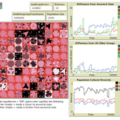
Local extinctions, connectedness, and cultural evolution in structured populations
Luke Premo | Published Tuesday, May 25, 2021This model is designed to address the following research question: How does the amount and topology of intergroup cultural transmission modulate the effect of local group extinction on selectively neutral cultural diversity in a geographically structured population? The experimental design varies group extinction rate, the amount of intergroup cultural transmission, and the topology of intergroup cultural transmission while measuring the effects of local group extinction on long-term cultural change and regional cultural differentiation in a constant-size, spatially structured population. The results show that for most of the intergroup social network topologies tested here, increasing the amount of intergroup cultural transmission (similar to increasing gene flow in a genetic model) erases the negative effect of local group extinction on selectively neutral cultural diversity. The stochastic (i.e., preference attachment) network seems to stand out as an exception.
Open Peer Review Model
Federico Bianchi | Published Monday, May 24, 2021This is an agent-based model of a population of scientists alternatively authoring or reviewing manuscripts submitted to a scholarly journal for peer review. Peer-review evaluation can be either ‘confidential’, i.e. the identity of authors and reviewers is not disclosed, or ‘open’, i.e. authors’ identity is disclosed to reviewers. The quality of the submitted manuscripts vary according to their authors’ resources, which vary according to the number of publications. Reviewers can assess the assigned manuscript’s quality either reliably of unreliably according to varying behavioural assumptions, i.e. direct/indirect reciprocation of past outcome as authors, or deference towards higher-status authors.
AIforGoodSimulator - Modeling Covid-19 Spread and Potential Interventions in Refugee Camps
Shyaam Ramkumar Woi Sok Oh | Published Thursday, March 18, 2021The Netlogo model is a conceptualization of the Moria refugee camp, capturing the household demographics of refugees in the camp, a theoretical friendship network based on values, and an abstraction of their daily activities. The model then simulates how Covid-19 could spread through the camp if one refugee is exposed to the virus, utilizing transmission probabilities and the stages of disease progression of Covid-19 from susceptible to exposed to asymptomatic / symptomatic to mild / severe to recovered from literature. The model also incorporates various interventions - PPE, lockdown, isolation of symptomatic refugees - to analyze how they could mitigate the spread of the virus through the camp.
Human Environment Estuarine Systems Investigator
Andrew Allison | Published Friday, February 26, 2021This model simulates the form and function of an idealised estuary with associated barrier-spit complex on the north east coast of New Zealand’s North Island (from Bream Bay to central Bay of Plenty) during the years 2010 - 2050 CE. It combines variables from social, ecological and geomorphic systems to simulate potential directions of change in shallow coastal systems in response to external forcing from land use, climate, pollution, population density, demographics, values and beliefs. The estuary is over 1000Ha, making it a large estuary according to Hume et al. (2007) - there are 12 large estuaries in the Auckland region alone (Suyadi et al., 2019). The model was developed as part of Andrew Allison’s PhD Thesis in Geography from the School of Environment and Institute of Marine Science, University of Auckland, New Zealand. The model setup allows for alteration of geomorphic, ecological and social variables to suit the specific conditions found in various estuaries along the north east coast of New Zealand’s North Island.
This model is not a predictive or forecasting model. It is designed to investigate potential directions of change in complex shallow coastal systems. This model must not be used for any purpose other than as a heuristic to facilitate researcher and stakeholder learning and for developing system understanding (as per Allison et al., 2018).
Hybrid agent-based methodology for testing response protocols
Fernando Sancho Caparrini | Published Wednesday, February 03, 2021In recent years we have seen multiple incidents with a large number of people injured and killed by one or more armed attackers. Since this type of violence is difficult to predict, detecting threats as early as possible allows to generate early warnings and reduce response time. In this context, any tool to check and compare different action protocols can be a further step in the direction of saving lives. Our proposal combines features from continuous and discrete models to obtain the best of both worlds in order to simulate large and crowded spaces where complex behavior individuals interact. With this proposal we aim to provide a tool for testing different security protocols under several emergency scenarios, where spaces, hazards, and population can be customized. Finally, we use a proof of concept implementation of this model to test specific security protocols under emergency situations for real spaces. Specifically, we test how providing some users of a university college with an app that informs about the type and characteristics of the ongoing hazard, affects in the safety performance.
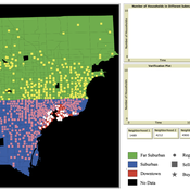
While the world’s total urban population continues to grow, not all cities are witnessing such growth, some are actually shrinking. This shrinkage causes several problems to emerge including population loss, economic depression, vacant properties and the contraction of housing markets. Such problems challenge efforts to make cities sustainable. While there is a growing body of work on study shrinking cities, few explore such a phenomenon from the bottom up using dynamic computational models. To overcome this issue this paper presents an spatially explicit agent-based model stylized on the Detroit Tri-county area, an area witnessing shrinkage. Specifically, the model demonstrates how through the buying and selling of houses can lead to urban shrinkage from the bottom up. The model results indicate that along with the lower level housing transactions being captured, the aggregated level market conditions relating to urban shrinkage are also captured (i.e., the contraction of housing markets). As such, the paper demonstrates the potential of simulation to explore urban shrinkage and potentially offers a means to test polices to achieve urban sustainability.
Can ethnic tolerance curb self-reinforcing school segregation? A theoretical Agent Based Model
Lucas Sage Andreas Flache | Published Monday, August 10, 2020Schelling and Sakoda prominently proposed computational models suggesting that strong ethnic residential segregation can be the unintended outcome of a self-reinforcing dynamic driven by choices of individuals with rather tolerant ethnic preferences. There are only few attempts to apply this view to school choice, another important arena in which ethnic segregation occurs. In the current paper, we explore with an agent-based theoretical model similar to those proposed for residential segregation, how ethnic tolerance among parents can affect the level of school segregation. More specifically, we ask whether and under which conditions school segregation could be reduced if more parents hold tolerant ethnic preferences. We move beyond earlier models of school segregation in three ways. First, we model individual school choices using a random utility discrete choice approach. Second, we vary the pattern of ethnic segregation in the residential context of school choices systematically, comparing residential maps in which segregation is unrelated to parents’ level of tolerance to residential maps reflecting their ethnic preferences. Third, we introduce heterogeneity in tolerance levels among parents belonging to the same group. Our simulation experiments suggest that ethnic school segregation can be a very robust phenomenon, occurring even when about half of the population prefers mixed to segregated schools. However, we also identify a “sweet spot” in the parameter space in which a larger proportion of tolerant parents makes the biggest difference. This is the case when parents have moderate preferences for nearby schools and there is only little residential segregation. Further experiments are presented that unravel the underlying mechanisms.
PopComp
Andre Costopoulos | Published Thursday, December 10, 2020PopComp by Andre Costopoulos 2020
[email protected]
Licence: DWYWWI (Do whatever you want with it)
I use Netlogo to build a simple environmental change and population expansion and diffusion model. Patches have a carrying capacity and can host two kinds of populations (APop and BPop). Each time step, the carrying capacity of each patch has a given probability of increasing or decreasing up to a maximum proportion.
…
Mitigating bioenergy-driven biodiversity decline: a modelling approach with the European brown hare
Maria Langhammer Volker Grimm | Published Wednesday, November 13, 2019 | Last modified Tuesday, November 24, 2020The model is designed to analyse the effects of mitigation measures on the European brown hare (Lepus europaeus), which is directly affected by ongoing land use change and has experienced widespread decline throughout Europe since the 1960s. As an input, we use two 4×4 km large model landscapes, which were generated by a landscape generator based on real field sizes and crop proportions and differed in average field size and crop composition. The crops grown annually are evaluated in terms of forage suitability, breeding suitability and crop richness for the hare. Six mitigation scenarios are implemented, defined by a 10 % increase in: (1) mixed silphie, (2) miscanthus, (3) grass-clover ley, (4) alfalfa, (5) set-aside, and (6) general crop richness. The model shows that that both landscape configuration and composition have a significant effect on hare population development, which responds particularly strongly to compositional changes.
Displaying 10 of 194 results population clear