Our mission is to help computational modelers develop, document, and share their computational models in accordance with community standards and good open science and software engineering practices. Model authors can publish their model source code in the Computational Model Library with narrative documentation as well as metadata that supports open science and emerging norms that facilitate software citation, computational reproducibility / frictionless reuse, and interoperability. Model authors can also request private peer review of their computational models. Models that pass peer review receive a DOI once published.
All users of models published in the library must cite model authors when they use and benefit from their code.
Please check out our model publishing tutorial and feel free to contact us if you have any questions or concerns about publishing your model(s) in the Computational Model Library.
Displaying 10 of 110 results for "Bert Devries" clear search
The Friendship Field
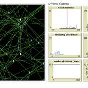
Eva Timmer Chrisja van de Kieft | Published Thursday, May 26, 2022 | Last modified Tuesday, August 30, 2022The Friendship Field model aims at modelling friendship formation based on three factors: Extraversion, Resemblance and Status, where social interaction is motivated by the Social Battery. Social Battery is one’s energy and motivation to engage in social contact. Since social contact is crucial for friendship formation, the model included Social Battery to affect social interactions. To our best knowledge, Social Battery is a yet unintroduced concept in research while it is a dynamic factor influencing the social interaction besides one’s characteristics. Extraverts’ Social Batteries charge while interacting and exhaust while being alone. Introverts’ Social Batteries charge while being alone and exhaust while interacting. The aim of the model is to illustrate the concept of Social Battery. Moreover, the Friendship Field shows patterns regarding Extraversion, Resemblance and Status including the mere-exposure effect and friendship by similarity. For the implementation of Status, Kemper’s status-power theory is used. The concept of Social Battery is also linked to Kemper’s theory on the organism as reference group. By running the model for a year (3 interactions moments per day), the friendship dynamics over time can be studied.
We presented the model at the Social Simulation Conference 2022.
Peter Diamond's Coconut Model (Heterogeneity and Learning)
Sven Banisch Eckehard Olbrich | Published Monday, May 30, 2016Agent-based version of the simple search and barter economy conceived by Peter Diamond in 1982. The model is also known as Coconut Model.
Policies to reconnect a city and the countryside
Gert Jan Hofstede Tim Verwaart | Published Monday, September 23, 2019The agent-based model captures the spatio-temporal institutional dynamics of the economy over the years at the level of a Dutch province. After 1945, Noord-Brabant in the Netherlands has been subject to an active program of economic development through the stimulation of pig husbandry. This has had far-reaching effects on its economy, landscape, and environment. The agents are households. The simulation is at institutional level, with typical stakeholder groups, lobbies, and political parties playing a role in determining policies that in turn determine economic, spatial and ecological outcomes. It allows to experiment with alternative scenarios based on two political dimensions: local versus global issues, and economic versus social responsibilitypriorities. The model shows very strong sensitivity to political context. It can serve as a reference model for other cases where “artificial institutional economics” is attempted.
Food Safety Inspection Model - Random Strategy
Sara Mcphee-Knowles | Published Wednesday, March 05, 2014 | Last modified Monday, April 08, 2019The Inspection Model represents a basic food safety system where inspectors, consumers and stores interact. The purpose of the model is to provide insight into an optimal level of inspectors in a food system by comparing three search strategies.
Food Safety Inspection Model - Stores Signal with Errors
Sara Mcphee-Knowles | Published Wednesday, March 05, 2014 | Last modified Monday, April 08, 2019The Inspection Model represents a basic food safety system where inspectors, consumers and stores interact. The purpose of the model is to provide insight into an optimal level of inspectors in a food system by comparing three search strategies.
Food Safety Inspection Model - Stores Signal
Sara Mcphee-Knowles | Published Wednesday, March 05, 2014 | Last modified Monday, August 26, 2019The Inspection Model represents a basic food safety system where inspectors, consumers and stores interact. The purpose of the model is to provide insight into an optimal level of inspectors in a food system by comparing three search strategies.
Competitive Arousal Agent Based Model
Zoé Chollet | Published Friday, May 13, 2022What is it?
This model demonstrates a very simple bidding market where buyers try to acquire a desired item at the best price in a competitive environment
…
Forager mobility and interaction
L S Premo | Published Thursday, January 10, 2013 | Last modified Saturday, April 27, 2013This is a relatively simple foraging-radius model, as described first by Robert Kelly, that allows one to quantify the effect of increased logistical mobility (as represented by increased effective foraging radius, r_e) on the likelihood that 2 randomly placed central place foragers will encounter one another within 5000 time steps.
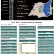
Peer reviewed Share: bottom-up disaster information management
Vittorio Nespeca Tina Comes Frances Brazier | Published Monday, December 05, 2022This model is intended to study the way information is collectively managed (i.e. shared, collected, processed, and stored) in a system and how it performs during a crisis or disaster. Performance is assessed in terms of the system’s ability to provide the information needed to the actors who need it when they need it. There are two main types of actors in the simulation, namely communities and professional responders. Their ability to exchange information is crucial to improve the system’s performance as each of them has direct access to only part of the information they need.
In a nutshell, the following occurs during a simulation. Due to a disaster, a series of randomly occurring disruptive events takes place. The actors in the simulation need to keep track of such events. Specifically, each event generates information needs for the different actors, which increases the information gaps (i.e. the “piles” of unaddressed information needs). In order to reduce the information gaps, the actors need to “discover” the pieces of information they need. The desired behavior or performance of the system is to keep the information gaps as low as possible, which is to address as many information needs as possible as they occur.
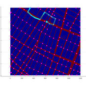
Agent-based model of WiFi tracking system in urban environment
Christopher Thron Khoi Tran | Published Friday, April 21, 2017This code simulates the WiFi user tracking system described in: Thron et al., “Design and Simulation of Sensor Networks for Tracking Wifi Users in Outdoor Urban Environments”. Testbenches used to create the figures in the paper are included.
Displaying 10 of 110 results for "Bert Devries" clear search