This models explores the spread of agriculture. It was designed to carry out experiments in the spread of agriculture to the Iberian peninsula, but could be applied to any other area of the world. This model does not assume a spread of farmers or farming ideas, but simply models the spread of farming practice under variable ecological conditions and with different ways of spreading geographically.
Several different spreading algorithms are available to the user (explained in more detail below). The starting point(s) of the spread of agriculture can be set interactively with a mouse or by importing a text file of xy coordinates (geospatial earth coordinates, not NetLogo world coordinates).
The GIS Extension allows the user to import a raster basemap in which cell values represent the suitability of the associated land for agriculture (applicable in several spread routines), and a vector map of known prehistoric farming sites. The time of arrival of agriculture (in model ticks) is recorded at each site, and site information can be saved at the end of a simulation run. The time of arrival of agriculture at each site in the simulation can then be compared with the real-world arrival of agriculture at the same sites.
Release Notes
Associated Publications
This release is out-of-date. The latest version is
2.1.0
Neolithic Spread Model Version 1.0 1.1.0
Submitted bySean BerginPublished Dec 11, 2014
Last modified Dec 31, 2018
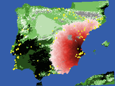
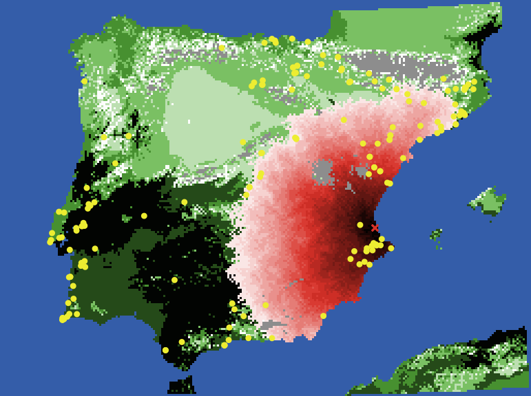
This models explores the spread of agriculture. It was designed to carry out experiments in the spread of agriculture to the Iberian peninsula, but could be applied to any other area of the world. This model does not assume a spread of farmers or farming ideas, but simply models the spread of farming practice under variable ecological conditions and with different ways of spreading geographically.
Several different spreading algorithms are available to the user (explained in more detail below). The starting point(s) of the spread of agriculture can be set interactively with a mouse or by importing a text file of xy coordinates (geospatial earth coordinates, not NetLogo world coordinates).
The GIS Extension allows the user to import a raster basemap in which cell values represent the suitability of the associated land for agriculture (applicable in several spread routines), and a vector map of known prehistoric farming sites. The time of arrival of agriculture (in model ticks) is recorded at each site, and site information can be saved at the end of a simulation run. The time of arrival of agriculture at each site in the simulation can then be compared with the real-world arrival of agriculture at the same sites.
Cite this Model
Sean Bergin, Michael Barton, Salvador Pardo Gordo, Joan Bernabeu Auban (2014, December 11). “Neolithic Spread Model Version 1.0” (Version 1.1.0). CoMSES Computational Model Library. Retrieved from: https://www.comses.net/codebases/4447/releases/1.1.0/
Create an Open Code Badge that links to this model more info
This model has not been reviewed by CoMSES Net and should be independently reviewed to
meet the Open Code Badge guidelines.
You can use the following HTML or Markdown code to create an Open Code Badge that links to
version 1.1.0
of this computational model.
This website uses cookies and Google Analytics to help us track user engagement and improve our site. If
you'd like to know more information about what data we collect and why, please see
our data privacy policy. If you continue to use this site, you consent to
our use of cookies.