About the CoMSES Model Library more info
Our mission is to help computational modelers at all levels engage in the establishment and adoption of community standards and good practices for developing and sharing computational models. Model authors can freely publish their model source code in the Computational Model Library alongside narrative documentation, open science metadata, and other emerging open science norms that facilitate software citation, reproducibility, interoperability, and reuse. Model authors can also request peer review of their computational models to receive a DOI.
All users of models published in the library must cite model authors when they use and benefit from their code.
Please check out our model publishing tutorial and contact us if you have any questions or concerns about publishing your model(s) in the Computational Model Library.
We also maintain a curated database of over 7500 publications of agent-based and individual based models with additional detailed metadata on availability of code and bibliometric information on the landscape of ABM/IBM publications that we welcome you to explore.
Displaying 5 of 5 results water scarcity clear search
The Urban Drought Nexus Tool
Roger Cremades Muhamad Khairulbahri | Published Thursday, December 14, 2023The “Urban Drought Nexus Tool” is a system dynamics model, aiming to facilitate the co-development of climate services for cities under increasing droughts. The tool integrates multiple types of information and still can be applied to other case studies with minimal adjustments on the parameters of land use, water consumption and energy use in the water sector. The tool needs hydrological projections under climate scenarios to evaluate climatic futures, and requires the co-creation of socio-economic future scenarios with local stakeholders. Thus it is possible to provide specific information about droughts taking into account future water availability and future water consumption. Ultimately, such complex system as formed by the water-energy-land nexus can be reduced to single variables of interest, e.g. the number of events with no water available in the future and their length, so that the complexities are reduced and the results can be conveyed to society in an understandable way, including the communication of uncertainties. The tool and an explanatory guide in pdf format are included. Planned further developments include calibrating the system dynamics model with the social dynamics behind each flow with agent-based models.
An integrated socio-economic Agent-Based Modeling framework towards assessing farmers’ decision making under water scarcity and varying utility function
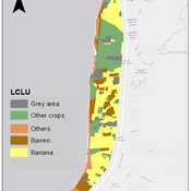
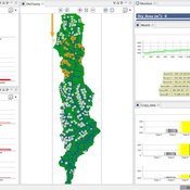
Ghinwa Harik | Published Tuesday, September 13, 2022 | Last modified Wednesday, November 23, 2022A spatio-temporal Agent Based Modeling (ABM) framework is developed to probabilistically predict farmers’ decisions in the context of climate-induced water scarcity under varying utility optimization functions. The proposed framework forecasts farmers’ behavior assuming varying utility functions. The framework allows decision makers to forecast the behavior of farmers through a user-friendly platform with clear output visualization. The functionality of the proposed ABM is illustrated in an agriculturally dominated plain along the Eastern Mediterranean coastline.
Study area GIS data available upon request to [email protected]
Samambaia Basin - Hydro-ABM
Pedro Phelipe Gonçalves Porto | Published Sunday, April 07, 2019 | Last modified Monday, May 06, 2019This model is a tool to support water management on Samambaia Basin. On it you can explore different scenarios of policy, management and externalities that could influence the water uses. (Scenarios already tested include less rain and payment on water use)
Peer reviewed From Individual Fuzzy Cognitive Maps to Agent Based Models: Modeling Multi-Factorial and Multi-stakeholder Decision-Making for Water Scarcity
Sara Mehryar | Published Monday, March 04, 2019 | Last modified Wednesday, August 28, 2019This model simulates different farmers’ decisions and actions to adapt to the water scarce situation. This simulation helps to investigate how farmers’ strategies may impact macro-behavior of the social-ecological system i.e. overall groundwater use change and emigration of farmers. The environmental variables’ behavior and behavioral rules of stakeholders are captured with Fuzzy Cognitive Map (FCM) that is developed with both qualitative and quantitative data, i.e. stakeholders’ knowledge and empirical data from studies. This model have been used to compare the impact of different water scarcity policies on overall groundwater use in a farming community facing water scarcity.
MEGADAPT - Socio-hydrological risk model - Theoretical (no data) implementation
Marco Janssen Andres Baeza-Castro Luis Bojorquez Hallie Eakin | Published Wednesday, February 06, 2019The model simulates the decisions of residents and a water authority to respond to socio-hydrological hazards. Residents from neighborhoods are located in a landscape with topographic complexity and two problems: water scarcity in the peripheral neighborhoods at high altitude and high risk of flooding in the lowlands, at the core of the city. The role of the water authority is to decide where investments in infrastructure should be allocated to reduce the risk to water scarcity and flooding events in the city, and these decisions are made via a multi-objective site selection procedure. This procedure accounts for the interdependencies and feedback between the urban landscape and a policy scenario that defines the importance, or priorities, that the authority places on four criteria.
Neighborhoods respond to the water authority decisions by protesting against the lack of investment and the level of exposure to water scarcity and flooding. Protests thus simulate a form of feedback between local-level outcomes (flooding and water scarcity) and higher-level decision-making. Neighborhoods at high altitude are more likely to be exposed to water scarcity and lack infrastructure, whereas neighborhoods in the lowlands tend to suffer from recurrent flooding. The frequency of flooding is also a function of spatially uniform rainfall events. Likewise, neighborhoods at the periphery of the urban landscape lack infrastructure and suffer from chronic risk of water scarcity.
The model simulates the coupling between the decision-making processes of institutional actors, socio-political processes and infrastructure-related hazards. In the documentation, we describe details of the implementation in NetLogo, the description of the procedures, scheduling, and the initial conditions of the landscape and the neighborhoods.
This work was supported by the National Science Foundation under Grant No. 1414052, CNH: The Dynamics of Multi-Scalar Adaptation in Megacities (PI Hallie Eakin).