Computational Model Library

Least cost path mobility (1.2.0)

This model tries to mimic human behavior in a topographical environment. It aims to go beyond the GIS approach to least-cost path that requires perfect knowledge of the whole environment to choose the best path between two points. This model is different in that the agent does not have a perfect knowledge of the whole surface, but rather evaluates the best path locally, at each step, thus mimicking imperfect human behavior more accurately. It relies on the work by Naismith (1892, in Aitken 1977) and Langmuir (1984) on walking time expenditure in rugged environments. Their walking time values are used to calculate the agent’s travel time.

v. 1.3.0 introduces the Lorentz mobility algorithm, created by Campbell et al. (2019) using fitness trackers. It also allows for multiple hikers and goals.

Screen_Shot_2017-09-02_at_2.41.00_PM.png

Release Notes

This new release fixes a bug that stopped the model when using “Import-2” mode if iter-start and iter-end were the same number even if those sites were not the same on the landscape.

It also allows using the maps without having to move them to a different folder.

Associated Publications

This release is out-of-date. The latest version is 2.0.0

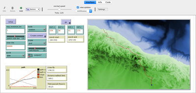
Least cost path mobility 1.2.0

This model tries to mimic human behavior in a topographical environment. It aims to go beyond the GIS approach to least-cost path that requires perfect knowledge of the whole environment to choose the best path between two points. This model is different in that the agent does not have a perfect knowledge of the whole surface, but rather evaluates the best path locally, at each step, thus mimicking imperfect human behavior more accurately. It relies on the work by Naismith (1892, in Aitken 1977) and Langmuir (1984) on walking time expenditure in rugged environments. Their walking time values are used to calculate the agent’s travel time.

v. 1.3.0 introduces the Lorentz mobility algorithm, created by Campbell et al. (2019) using fitness trackers. It also allows for multiple hikers and goals.

Release Notes

This new release fixes a bug that stopped the model when using “Import-2” mode if iter-start and iter-end were the same number even if those sites were not the same on the landscape.

It also allows using the maps without having to move them to a different folder.

Version Submitter First published Last modified Status
2.0.0 Claudine Gravel-Miguel Mon Oct 4 20:33:41 2021 Mon Oct 4 20:33:41 2021 Published
1.2.0 Claudine Gravel-Miguel Thu May 30 23:20:23 2019 Fri May 31 04:48:53 2019 Published Peer Reviewed https://doi.org/10.25937/p68v-0z64
1.1.0 Claudine Gravel-Miguel Wed Aug 29 17:06:37 2018 Thu Apr 18 18:45:31 2019 Published

Discussion

This website uses cookies and Google Analytics to help us track user engagement and improve our site. If you'd like to know more information about what data we collect and why, please see our data privacy policy. If you continue to use this site, you consent to our use of cookies.
Accept