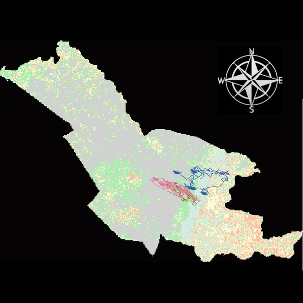
Agent modeling (ABM) as a tool to improve the mobility of “avoidant” birds in an ecological corridor in the localities of Chapinero, Teusaquillo, Barrios Unidos and Engativá of Bogotá city [Scenario 2] (1.0.2)
Considering that two of the three avoider species could not reach the target area in the inittial scenario, five alternative corridor scenarios were created. In all cases, we generated a greater amount of cover area under ‘Urban forest’, including elements such as scattered trees, woody plants, wooded areas, and rows of trees. This covered type was selected since all three species use it as a regular habitat. That is the second sceneario where those ecological parks and other areas inside the capital city were boostered into “urban forest patches” or buffer points, with the idea of improving the survive of the three bird species and their movement. However one of the most restrictive specie was still having movement and survival issues.
Release Notes
ABM Model: Ecological corridor Bogotá
Mobility of urban-avoider birds in Chapinero, Teusaquillo, Barrios Unidos and Engativá.
Version V.11: scenario 1
Tempral Scale 1tick = 1 hour
Plataform: NetLogo 6.4.0
Spatial scale: Local (just 4 urban areas)
Upload AVARBOLESVerdes4.asc, Rosavientosnegra.png and amormio.asc documents if you want that the model show you the modifications. amormio.asc it’s the innitial raster and where is the modifications are inside AVARBOLESVerdes4.asc. However, to make the model work, both layers must be uploaded.
Three agents defined (juvenile urban-avoider birds). “Ampelion rubrocristatus (frugivore). Chondrohierax uncinatus (carnivore). Coeligena bonapartei (nectivore)”.
5 posibilities of patches.
Agent energy based on maths ecuations “EM” and “EMB”
Three genaral behaviours: Die; Move; Eat
EEP land-cover patches regenerate every 24 ticks (daily cycle)
Only Main Ecological Structure (EEP) covers regenerate. All other land covers remain constant.
Altitudinal range of study area: 1,000–3,500 m a.s.l.
Five ecological corridor scenarios modelled which it’s related between the interaction of agents (birds), patches (land posibilities) and their achievement upon reaching the designated area (Simón Bolívar Park). This is the initial scenario, from which 5 more were generated.
Associated Publications
Innitial model: https://www.comses.net/codebase-release/65b0ab41-d6bd-45de-980d-4f277e536c8d/
Scenario 1: https://www.comses.net/codebase-release/2d5a3488-b339-4e94-8ed4-ae7293b2ab91/
Echeverry-Galvis, M. A., Ramírez, P. L., & Amaya-Espinel, J. D. (2023). Long-term Christmas Bird Counts describe neotropical urban bird diversity. PLOS ONE, 18(2), e0272754. https://doi.org/10.1371/journal.pone.0272754
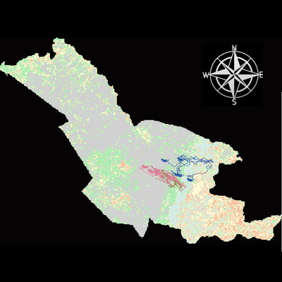
Agent modeling (ABM) as a tool to improve the mobility of “avoidant” birds in an ecological corridor in the localities of Chapinero, Teusaquillo, Barrios Unidos and Engativá of Bogotá city [Scenario 2] 1.0.2
Considering that two of the three avoider species could not reach the target area in the inittial scenario, five alternative corridor scenarios were created. In all cases, we generated a greater amount of cover area under ‘Urban forest’, including elements such as scattered trees, woody plants, wooded areas, and rows of trees. This covered type was selected since all three species use it as a regular habitat. That is the second sceneario where those ecological parks and other areas inside the capital city were boostered into “urban forest patches” or buffer points, with the idea of improving the survive of the three bird species and their movement. However one of the most restrictive specie was still having movement and survival issues.
Release Notes
ABM Model: Ecological corridor Bogotá
Mobility of urban-avoider birds in Chapinero, Teusaquillo, Barrios Unidos and Engativá.
Version V.11: scenario 1
Tempral Scale 1tick = 1 hour
Plataform: NetLogo 6.4.0
Spatial scale: Local (just 4 urban areas)
Upload AVARBOLESVerdes4.asc, Rosavientosnegra.png and amormio.asc documents if you want that the model show you the modifications. amormio.asc it’s the innitial raster and where is the modifications are inside AVARBOLESVerdes4.asc. However, to make the model work, both layers must be uploaded.
Three agents defined (juvenile urban-avoider birds). “Ampelion rubrocristatus (frugivore). Chondrohierax uncinatus (carnivore). Coeligena bonapartei (nectivore)”.
5 posibilities of patches.
Agent energy based on maths ecuations “EM” and “EMB”
Three genaral behaviours: Die; Move; Eat
EEP land-cover patches regenerate every 24 ticks (daily cycle)
Only Main Ecological Structure (EEP) covers regenerate. All other land covers remain constant.
Altitudinal range of study area: 1,000–3,500 m a.s.l.
Five ecological corridor scenarios modelled which it’s related between the interaction of agents (birds), patches (land posibilities) and their achievement upon reaching the designated area (Simón Bolívar Park). This is the initial scenario, from which 5 more were generated.