Cluster Analysis (1.0.0)
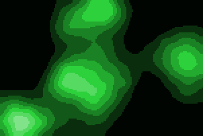
The analysis is highly interactive and does not claim to be statistically relevant. The model can be used to see where points are concentrated. The analysis summarizes points within two distances based on each patch. The result creates an image similar to elevation curves.
Release Notes
Version 2. Several new functions has been added and the analysis now calculate two distances
Associated Publications
A previous version has been published here by the same author.
Cluster Analysis 1.0.0
Submitted by
Lars Spång
Published Jan 14, 2018
Last modified Feb 23, 2018
The analysis is highly interactive and does not claim to be statistically relevant. The model can be used to see where points are concentrated. The analysis summarizes points within two distances based on each patch. The result creates an image similar to elevation curves.
Release Notes
Version 2. Several new functions has been added and the analysis now calculate two distances
