
Liliana Perez
Affiliations Personal homepage Professional homepage ORCID more infohttps://orcid.org/0000-0002-6599-9893
GitHub more infoNo associated GitHub account.
My initial training was in cadastre and geodesy (B.Eng from the Distrital University, UD, Colombia). After earning my Master’s degree in Geography (UPTC, Colombia) in 2003, I worked for the “José Benito Vives de Andreis” marine and coastal research institute (INVEMAR) and for the International Center for Tropical Agriculture (CIAT). Three years later, in 2006, I left Colombia to come to Canada, where I began a PhD in Geography with a specialization in modelling complex systems at Simon Fraser University (SFU), under the direction of Dr. Suzana Dragicevic (SAMLab). In my dissertation I examined the topic of spatial and temporal modelling of insect epidemics and their complex behaviours. After obtaining my PhD in 2011, I began postdoctoral studies at the University of British Columbia (2011) and the University of Victoria (2011-2013), where I worked on issues concerning the spatial and temporal relationships between changes in indirect indicators of biodiversity and climate change.
Research Interests
I am an Associate Professor in the Department of Geography at the University of Montreal. My research interests center around the incorporation of artificial intelligence and machine learning techniques into the development Agent-Based Models to solve complex socio-ecological problems in different kind of systems, such as urban, forest and wetland ecosystems.
The core of my research projects aim to learn more about spatial and temporal interactions and relationships driving changes in our world, by focusing on the multidisciplinary nature of geographical information science (GIScience) to investigate the relationships between ecological processes and resulting spatial patterns. I integrate spatial analysis and modeling approaches from geographic information science (GIScience) together with computational intelligence methods and complex systems approaches to provide insights into complex problems such as climate change, landscape ecology and forestry by explicitly representing phenomena in their geographic context.
Specialties: Agent-based modeling, GIScience, Complex socio-environmental systems, Forestry, Ecology

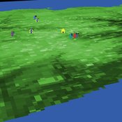
An age and/or gender-based division of labor during the Last Glacial Maximum in Iberia through rabbit hunting
Samuel Seuru Ariane Burke Liliana Perez | Published Thursday, February 29, 2024Many archaeological assemblages from the Iberian Peninsula dated to the Last Glacial Maximum contain large quantities of European rabbit (Oryctolagus cuniculus) remains with an anthropic origin. Ethnographic and historic studies report that rabbits may be mass-collected through warren-based harvesting involving the collaborative participation of several persons.
We propose and implement an Agent-Based Model grounded in the Optimal Foraging Theory and the Diet Breadth Model to examine how different warren-based hunting strategies influence the resulting human diets.
…
An age and/or gender-based division of labor during the Last Glacial Maximum in Iberia through rabbit hunting
Samuel Seuru Ariane Burke Liliana Perez | Published Friday, July 07, 2023Many archaeological assemblages from the Iberian Peninsula dated to the Last Glacial Maximum contain large quantities of European rabbit (Oryctolagus cuniculus) remains with an anthropic origin. Ethnographic and historic studies report that rabbits may be mass-collected through warren-based harvesting involving the collaborative participation of several persons.
We propose and implement an Agent-Based Model grounded in the Optimal Foraging Theory and the Diet Breadth Model to examine how different warren-based hunting strategies influence the resulting human diets.
Particularly, this model is developed to test the following hypothesis: What if an age and/or gender-based division of labor was adopted, in which adult men focus on large prey hunting, and women, elders and children exploit warrens?
…
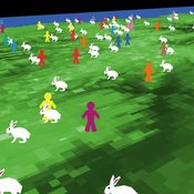
PalaeoDiet : Rabbit hunting during the Upper Palaeolithic
Samuel Seuru Liliana Perez Ariane Burke | Published Thursday, October 06, 2022Zooarchaeological evidences indicate that rabbit hunting became prevalent during the Upper Palaeolithic in the Iberian Peninsula.
The purpose of the ABM is to test if warren hunting using nets as a collective strategy can explain the introduction of rabbits in the human diet in the Iberian Peninsula during this period. It is analyzed whether this hunting strategy has an impact on human diet breadth by affecting the relative abundance of other main taxa in the dietary spectrum.
Model validity is measured by comparing simulated diet breadth to the observed diet breadth in the zooarchaeological record.
The agent-based model is explicitly grounded on the Diet Breadth Model (DBM), from the Optimal Foraging Theory (OFT).
…
The Agent-Based Wildfire Simulation Environment (ABWiSE) translates the concept of a moving fire front as a set of mobile fire agents that respond to, and interact with, vegetation, wind, and terrain. Presently, the purpose of ABWiSE is to explore how ABM, using simple interactions between agents and a simple atmospheric feedback model, can simulate emergent fire spread patterns.
FlipFlop1-ProMEERB: A coupled social-ecological model with a promotional mechanism for emergence of environmentally responsible behavior
Saeed Harati Liliana Perez Roberto Molowny-Horas | Published Friday, December 17, 2021At the heart of a study of Social-Ecological Systems, this model is built by coupling together two independently developed models of social and ecological phenomena. The social component of the model is an abstract model of interactions of a governing agent and several user agents, where the governing agent aims to promote a particular behavior among the user agents. The ecological model is a spatial model of spread of the Mountain Pine Beetle in the forests of British Columbia, Canada. The coupled model allowed us to simulate various hypothetical management scenarios in a context of forest insect infestations. The social and ecological components of this model are developed in two different environments. In order to establish the connection between those components, this model is equipped with a ‘FlipFlop’ - a structure of storage directories and communication protocols which allows each of the models to process its inputs, send an output message to the other, and/or wait for an input message from the other, when necessary. To see the publications associated with the social and ecological components of this coupled model please see the References section.
Mobility, Ethnicity, and Language-Based Immigrant Settlement Model - MELBIS
Liliana Perez Suzana Dragicevic Taylor Anderson Jonathan Gaudreau Aaron Leung | Published Monday, June 14, 2021 | Last modified Monday, June 14, 2021MELBIS-V1 is a spatially explicit agent-based model that allows the geospatial simulation of the decision-making process of newcomers arriving in the bilingual cities and boroughs of the island of Montreal, Quebec in CANADA, and the resulting urban segregation spatial patterns. The model was implemented in NetLogo, using geospatial raster datasets of 120m spatial resolution.
MELBIS-V2 enhances MELBIS-V1 to implement and simulate the decision-making processes of incoming immigrants, and to analyze the resulting spatial patterns of segregation as immigrants arrive and settle in various cities in Canada. The arrival and segregation of immigrants is modeled with MELBIS-V2 and compared for three major Canadian immigration gateways, including the City of Toronto, Metro Vancouver, and the City of Calgary.
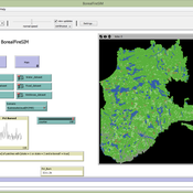
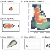
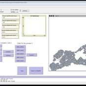
BorealFireSIM is a cellular automaton based model that serves to identify future fire patterns in the boreal forest of Quebec, Canada. The model simulates yearly fire seasons and adjusts decadal climate variables based on two future carbon pathways (RCP45 (low emissions) and RCP85 (business as usual)). The BorealFireSIM model simulates future fire patterns up to the year 2100.
RefugeePathSIM Model
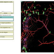
Guillaume Arnoux Hébert Liliana Perez Saeed Harati | Published Thursday, October 11, 2018 | Last modified Tuesday, October 16, 2018RefugeePathSIM is an agent-based model to simulate the movement behavior of refugees in order to identify pathways of forced migration under crisis. The model generates migrants and lets them leave conflict areas for a destination that they choose based on their characteristics and desires. RefugeePathSIM has been developed and applied in a study of the Syrian war, using monthly data in years 2011-2015.
Under development.