About the CoMSES Model Library more info
Our mission is to help computational modelers at all levels engage in the establishment and adoption of community standards and good practices for developing and sharing computational models. Model authors can freely publish their model source code in the Computational Model Library alongside narrative documentation, open science metadata, and other emerging open science norms that facilitate software citation, reproducibility, interoperability, and reuse. Model authors can also request peer review of their computational models to receive a DOI.
All users of models published in the library must cite model authors when they use and benefit from their code.
Please check out our model publishing tutorial and contact us if you have any questions or concerns about publishing your model(s) in the Computational Model Library.
We also maintain a curated database of over 7500 publications of agent-based and individual based models with additional detailed metadata on availability of code and bibliometric information on the landscape of ABM/IBM publications that we welcome you to explore.
Displaying 7 of 27 results gis clear
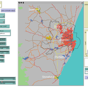
Transport simulation in a real road network
Jiaqi Ge Gary Polhill | Published Tuesday, April 17, 2018 | Last modified Tuesday, April 17, 2018Ge, J., & Polhill, G. (2016). Exploring the Combined Impact of Factors Influencing Commuting Patterns and CO2 Emission in Aberdeen Using an Agent-Based Model. Journal of Artificial Societies and Social Simulation, 19(3). http://jasss.soc.surrey.ac.uk/19/3/11.html
We develop an agent-based transport model using a realistic GIS-enabled road network and the car following method. The model can be used to study the impact of social interventions such as flexi-time and workplace sharing, as well as large infrastructure such as the construction of a bypass or highway. The model is developed in Netlogo version 5 and requires road network data in GIS format to run.
Modeling the Emergence of Riots
Bianica Pires Andrew Crooks | Published Wednesday, January 20, 2016 | Last modified Wednesday, September 21, 2016The purpose of the model is to explore how the unique socioeconomic variables underlying Kibera, local interactions, and the spread of a rumor, may trigger a riot.
The AgriculTural LandscApe Simulator (ATLAS)
Hugo Thierry Aude Vialatte Jean-Philippe Choisis Benoit Gaudou Hazel Parry Claude Monteil | Published Monday, January 30, 2017 | Last modified Wednesday, May 10, 2017The spatially-explicit AgriculTuralLandscApe Simulator (ATLAS) simulates realistic spatial-temporal crop availability at the landscape scale through crop rotations and crop phenology.
The Geography of Conflict Diamonds: The Case of Sierra Leone
Bianica Pires Andrew Crooks | Published Thursday, March 24, 2016 | Last modified Thursday, March 24, 2016Using Sierra Leone as a test case, the purpose of the model is to explore the role of geography in a resource-driven war. An ABM is integrated with geographic information systems (GIS) for this purpose.
Population Dynamics of Emerald Ash Borer
mpeters | Published Monday, December 13, 2010 | Last modified Saturday, April 27, 2013This model was developed as part of a class project, and explores the population dynamics and spread of an invasive insect, Emerald Ash Borer, in a county.
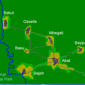
A stylized scale model to codesign with villagers an agent-based model of bushmeat hunting in the periphery of Korup National Park (Cameroon)
Socio-spatial segregation in Salzburg, Austria
Andreas Koch | Published Friday, September 25, 2009 | Last modified Saturday, April 27, 2013This is a first preliminary simulation model to model segregation in the city of Salzburg, Austria.
Displaying 7 of 27 results gis clear