About the CoMSES Model Library more info
Our mission is to help computational modelers at all levels engage in the establishment and adoption of community standards and good practices for developing and sharing computational models. Model authors can freely publish their model source code in the Computational Model Library alongside narrative documentation, open science metadata, and other emerging open science norms that facilitate software citation, reproducibility, interoperability, and reuse. Model authors can also request peer review of their computational models to receive a DOI.
All users of models published in the library must cite model authors when they use and benefit from their code.
Please check out our model publishing tutorial and contact us if you have any questions or concerns about publishing your model(s) in the Computational Model Library.
We also maintain a curated database of over 7500 publications of agent-based and individual based models with additional detailed metadata on availability of code and bibliometric information on the landscape of ABM/IBM publications that we welcome you to explore.
Displaying 9 of 9 results exposure clear
Simulation of Dual Information Exposure Networks: An Agent-Based Model of Panic Buying Behavior in China
dachenga | Published Thursday, April 11, 2024The main function of this simulation model is to simulate the onset of individual panic in the context of a public health event, and in particular to simulate how an individual’s panic develops and dies out in the context of a dual information contact network of online social media information and offline in-person perception information. In this model, eight different scenarios are set up by adjusting key parameters according to the difference in the amount and nature of information circulating in the dual information network, in order to observe how the agent’s panic behavior will change under different information exposure situations.
The Friendship Field
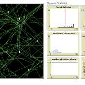
Eva Timmer Chrisja van de Kieft | Published Thursday, May 26, 2022 | Last modified Tuesday, August 30, 2022The Friendship Field model aims at modelling friendship formation based on three factors: Extraversion, Resemblance and Status, where social interaction is motivated by the Social Battery. Social Battery is one’s energy and motivation to engage in social contact. Since social contact is crucial for friendship formation, the model included Social Battery to affect social interactions. To our best knowledge, Social Battery is a yet unintroduced concept in research while it is a dynamic factor influencing the social interaction besides one’s characteristics. Extraverts’ Social Batteries charge while interacting and exhaust while being alone. Introverts’ Social Batteries charge while being alone and exhaust while interacting. The aim of the model is to illustrate the concept of Social Battery. Moreover, the Friendship Field shows patterns regarding Extraversion, Resemblance and Status including the mere-exposure effect and friendship by similarity. For the implementation of Status, Kemper’s status-power theory is used. The concept of Social Battery is also linked to Kemper’s theory on the organism as reference group. By running the model for a year (3 interactions moments per day), the friendship dynamics over time can be studied.
We presented the model at the Social Simulation Conference 2022.
A replication and extension of the Taylor's Simulation Model of Insurance Market Dynamics in C#
Rei England | Published Sunday, September 24, 2023A simple model is constructed using C# in order to to capture key features of market dynamics, while also producing reasonable results for the individual insurers. A replication of Taylor’s model is also constructed in order to compare results with the new premium setting mechanism. To enable the comparison of the two premium mechanisms, the rest of the model set-up is maintained as in the Taylor model. As in the Taylor example, homogeneous customers represented as a total market exposure which is allocated amongst the insurers.
In each time period, the model undergoes the following steps:
1. Insurers set competitive premiums per exposure unit
2. Losses are generated based on each insurer’s share of the market exposure
3. Accounting results are calculated for each insurer
…
EMMIT (Extendable Model for Malaria Intervention Testing)
Jacob Heintzelman Greg R Madey | Published Thursday, May 27, 2021EMMIT is an end-user developed agent-based simulation of malaria transmission. The simulation’s development is a case study demonstrating an approach for non-technical investigators to easily develop useful simulations of complex public health problems. We focused on malaria transmission, a major global public health problem, and insecticide resistance (IR), a major problem affecting malaria control. Insecticides are used to reduce transmission of malaria caused by the Plasmodium parasite that is spread by the Anopheles mosquito. However, the emergence and spread of IR in a mosquito population can diminish the insecticide’s effectiveness. IR results from mutations that produce behavioral changes or biochemical changes (such as detoxification enhancement, target site alterations) in the mosquito population that provide resistance to the insecticide. Evolutionary selection for the IR traits reduces the effectiveness of an insecticide favoring the resistant mosquito population. It has been suggested that biopesticides, and specifically those that are Late Life Acting (LLA), could address this problem. LLA insecticides exploit Plasmodium’s approximate 10-day extrinsic incubation period in the mosquito vector, a delay that limits malaria transmission to older infected mosquitoes. Since the proposed LLA insecticide delays mosquito death until after the exposed mosquito has a chance to produce several broods of offspring, reducing the selective pressure for resistance, it delays IR development and gives the insecticide longer effectivity. Such insecticides are designed to slow the evolution of IR thus maintaining their effectiveness for malaria control. For the IR problem, EMMIT shows that an LLA insecticide could work as intended, but its operational characteristics are critical, primarily the mean-time-to-death after exposure and the associated standard deviation. We also demonstrate the simulation’s extensibility to other malaria control measures, including larval source control and policies to mitigate the spread of IR. The simulation was developed using NetLogo as a case study of a simple but useful approach to public health research.
MCR Model
Davide Secchi Nuno R Barros De Oliveira | Published Friday, July 22, 2016 | Last modified Saturday, January 23, 2021The aim of the model is to define when researcher’s assumptions of dependence or independence of cases in multiple case study research affect the results — hence, the understanding of these cases.
Dynamic Interbank Network Simulator
Valentina Guleva | Published Wednesday, November 23, 2016 | Last modified Monday, April 13, 2020The model provides instruments for the simulation of interbank network evolution. There are tools for dynamic network analysis, allowing to evaluate graph topological invariants, thermodynamic network features and combinational node-based features.
MEGADAPT - Socio-hydrological risk model - Theoretical (no data) implementation
Andres Baeza-Castro Luis Bojorquez Marco Janssen Hallie Eakin | Published Wednesday, February 06, 2019The model simulates the decisions of residents and a water authority to respond to socio-hydrological hazards. Residents from neighborhoods are located in a landscape with topographic complexity and two problems: water scarcity in the peripheral neighborhoods at high altitude and high risk of flooding in the lowlands, at the core of the city. The role of the water authority is to decide where investments in infrastructure should be allocated to reduce the risk to water scarcity and flooding events in the city, and these decisions are made via a multi-objective site selection procedure. This procedure accounts for the interdependencies and feedback between the urban landscape and a policy scenario that defines the importance, or priorities, that the authority places on four criteria.
Neighborhoods respond to the water authority decisions by protesting against the lack of investment and the level of exposure to water scarcity and flooding. Protests thus simulate a form of feedback between local-level outcomes (flooding and water scarcity) and higher-level decision-making. Neighborhoods at high altitude are more likely to be exposed to water scarcity and lack infrastructure, whereas neighborhoods in the lowlands tend to suffer from recurrent flooding. The frequency of flooding is also a function of spatially uniform rainfall events. Likewise, neighborhoods at the periphery of the urban landscape lack infrastructure and suffer from chronic risk of water scarcity.
The model simulates the coupling between the decision-making processes of institutional actors, socio-political processes and infrastructure-related hazards. In the documentation, we describe details of the implementation in NetLogo, the description of the procedures, scheduling, and the initial conditions of the landscape and the neighborhoods.
This work was supported by the National Science Foundation under Grant No. 1414052, CNH: The Dynamics of Multi-Scalar Adaptation in Megacities (PI Hallie Eakin).
Peer reviewed The foraging potential of the Holocene Cape South Coast of South Africa without the Palaeo-Agulhas Plain
Colin Wren Marco Janssen | Published Monday, August 12, 2019The Palaeo-Agulhas Plain formed an important habitat exploited by Pleistocene hunter-gatherer populations during periods of lower sea level. This productive, grassy habitat would have supported numerous large-bodied ungulates accessible to a population of skilled hunters with the right hunting technology. It also provided a potentially rich location for plant food collection, and along its shores a coastline that moved with the rise and fall of sea levels. The rich archaeological and paleontological records of Pleistocene sites along the modern Cape south coast of South Africa, which would have overlooked the Palaeo-Agulhas Plain during Pleistocene times of lower sea level, provides a paleoarchive of this extinct ecosystem. In this paper, we present a first order illustration of the “palaeoscape modeling” approach advocated by Marean et al. (2015). We use a resourcescape model created from modern studies of habitat productivity without the Palaeo-Agulhas Plain. This is equivalent to predominant Holocene conditions. We then run an agent-based model of the human foraging system to investigate several research questions. Our agent-based approach uses the theoretical framework of optimal foraging theory to model human foraging decisions designed to optimize the net caloric gains within a complex landscape of spatially and temporally variable resources. We find that during the high sea-levels of MIS 5e (+5-6 m asl) and the Holocene, the absence of the Plain left a relatively poor food base supporting a much smaller population relying heavily on edible plant resources from the current Cape flora. Despite high species diversity of plants with edible storage organs, and marine invertebrates, encounter rates with highly profitable resources were low. We demonstrate that without the Palaeo-Agulhas Plain, human populations must have been small and low density, and exploited plant, mammal, and marine resources with relatively low caloric returns. The exposure and contraction of the Palaeo-Agulhas Plain was likely the single biggest driver of behavioral change during periods of climate change through the Pleistocene and into the transition to the Holocene.
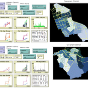
An Agent-based Assessment of Health Vulnerability to Long-term particulate exposure in Seoul Districts
Hyesop Shin Mike Bithell | Published Monday, November 05, 2018 | Last modified Monday, December 03, 2018This model aims to understand the cumulative effects on the population’s vulnerability as represented by exposure to PM10 (particulate matter with diameter less than 10 micrometres) by different age and educational groups in two Seoul districts, Gangnam and Gwanak. Using this model, readers can explore individual’s daily commuting routine, and its health loss when the PM10 concentration of the current patch breaches the national limit of 100µg/m3.